There comes a time when one must consider whether one is confirming the truth, or if one is conforming the truth. This page is dedicated as a meditation into the bias confirmation trap.
On this page are the best evidence pertaining to the "Flat Earth" scenario.
The question is, if a perception is evident, is it true only because it makes sense?

* " 'The Earth is flat': Retired NBA star Shaquille O’Neal" (2017-03-20, rt.com/sport/381527-earth-is-flat-shaquille-oneal/) [archive.is/MKPpM]
* " ‘I’m looking for the curve’: US rapper raising funds to prove Flat Earth theory" (2017-09-26, rt.com/usa/404691-flat-earth-theory-bob-rapper/) [archive.fo/p1GTo]

* Flat Earth Society's Shenton Archives - Lecture Posters (theflatearthsociety.org/home/index.php/featured/shenton-archives-lecture-notes) [archive.is/3nwka]

* "The Best Flat Earth Documentary" (6 hours) [youtu.be/GhRiLP32qfs]
* "NASA's Fake Ball Earth vs The True Flat Earth" [youtube.com/watch?v=xHwfVn4xZFY]
* "Sun, Moon, and Stars Prove the Flat Earth" [youtube.com/watch?v=P5LzJrVKmBk]
* "Under The Dome" [youtube.com/watch?v=fk4YqPtvJao]
* "Unedited NASA footage of "moon landing" - You still don't believe in a flat earth?" [youtube.com/watch?v=zdFqK1wTx0A]
[youtube.com/watch?v=Fshgj-1Gq2w]
* "200 Proofs Earth is Not a Spinning Ball" [archive.is/hC7hG]
* "200 Proofs Earth is Not a Spinning Ball Videobook" [youtube.com/watch?v=h5i_iDyUTCg]
* "Plane Not A Planet" [aplanetruth.info], The First Ever Flat Earth Website... Helping to end 500 years of One Massive Lie.
* "INTRODUCTION TO THE FLAT EARTH, HOW IT WORKS, AND WHY WE BELIEVE IT" (2016-02-16, flatearthscienceandbible.wordpress.com) [archive.is/pV6F5]
===*===*===
Flat Earth... debunked!
* "200 Proofs: Examined, Rebuttals and Refutations" [archive.is/q5fOB]
* "The Flat-Earth/ Round Earth Controversy" (modified 1986, originally by Stanley Weinberg) (.pdf) [is.gd/DAi3Ls]
* "Why the Flat Earth is Not Biblical" (refuteit.com) [archive.is/IoHLw]
* "Another example of why the flat earth theory is wrong" [archive.is/qEg9k]
* "Flat Earth Insanity: Catalog of Flat Earth Claims & Refutations" [flatearthinsanity.blogspot.com/2016/11/catalog-of-flat-earth-claims-refutations.html]
* "Popular Fallacy: Flat Earth; It was a 17th-century fabrication that scholars ever believed the earth to be a flat disc" [archive.is/31NwH]:
It was a 17th-century fabrication that scholars ever believed the earth to be a flat disc.
Although the earliest surviving globe was made in 1492, serious scholars of the planets had realised centuries before that the earth was not a flat disc. In his book on astronomy, Liber de Sphaera, published around 1230, Johannes de Sacrobosco described the earth as a spherical ball. And much earlier, in the 8th century, a monk named Beda had categorically called it a "rotunda". He based his claim on the works of the Greek philosopher Aristotle (4th century BC), whose countryman Eratosthenes had made a nearly accurate calculation of the earth's circumference being between 6,000 and 8,000km—the actual figure is 6,350km. The Roman historian Pliny also noted empirical grounds for the spherical theory: the lower part of a ship at the horizon seemed to 'sink' into the sea, and the earth's shadow on the moon was always circular, which would not be possible if the earth were flat.

===*===*===
Flat Earth maps & books -
* "The Flat Earth" (by Donald E. Simanek, lhup.edu) [archive.is/wgwKt] [begin excerpt]:
Revival of Flat Earth Theories.
Bob Shadewald, who researced the flat earth idea to a greater extent than I have, tells me that the flat earth idea was revived in the 18th century by the followers of a eccentric English sectarian and tailor, Lodowick Muggleton. I have been unable to independently confirm this. Origins of eccentric ideas are usually difficult to pin down. In any case, from the 18th century to the present day the flat earth belief is bound up with religious fundamentalism.
By 1800, Zetetic societies were flourishing in England. 'Zetetic' means 'seeker' or 'skeptic'. The flat-earthers took this name to symbolize their skepticism toward orthodox scientific views of the shape of the earth.
However, their skepticism was limited to science. Then, and now, the flat idea goes along with religious fundamentalism, and a literal interpretation of the Bible. I have yet to hear of a flat earther who is not also a Biblical literalist.
Samuel Birley Rowbotham (1816-1884), a 19th century religious fundamentalist, headed an Owenite colony, and promoted the flat earth philosophy. He's a shadowy figure for historians. He had a reputation of cynical dishonesty, and some think he didn't really believe what he promoted. He was an itinerant lecurer, and wrote under several pseudonyms: Tryon, S. Goulden, Parallax, and Dr. Birley. His major work was Earth Not a Globe written in 1849.
Rowbotham concocted the fiendishly clever idea of light refraction in curved paths to 'save the hypothesis' of the flat earth, to account for what he called the 'optical illusions' of sunrise and sunset. Rowbotham is the first flat-earther to give the size of the sun: 32 miles in diameter, a figure accepted by flat-earthers today. However, he gave the distance to the sun as 700 miles, a figure hard to reconcile with his value for its diameter.
John Hampden (1819-1891) vigorously promoted the flat earth idea in England. He founded the Truth-Seeker's Oracle and Scriptural Science Review in 1876. In 1870 Hampden made a bet with naturalist Alfred Wallace on the outcome of a test of the flatness of water in the Old Bedford Canal. Both sides claimed the test confirmed their view, and flat-earthers to this day assert that "water surfaces have been proved to be flat."
Hampden was known for his piety, and his abusive language. Feeling he had been wronged in the Bedford experiment, he buried Wallace in a blizzard of vitriolic pamphlets and letters to the editor. [...]
Hampden thought the sun only 600 miles away, and 32 miles in diameter. These numbers derived from Rowotham, and added nothing new to flat earth theory.
After Rowbotham's death in 1884 his followers carried on the crusade. The Universal Zetetic Society (UZS) was founded in 1890, publishing a journal titled The Earth Not a Globe Review which had 1000 subscribers. The UZS remained active well into the early 20th century, but slowly declined after World War I.
Other flat-earthers were active at this time. William Carpenter emigrated to Baltimore and wrote One Hundred Proofs that the Earth is not a Globe in 1885. Lady Blount, wife of Sir Walter de Sodrington Blount, promoted flat earth ideas. She founded and edited a journal Earth from 1900 to 1904. Scotsman John Alexander Dowie (1847-1907) studied at Edinburgh University, then established a pastorate near Sydney Australia, and included flat earth dogma in his theology. [end excerpt]
---
Flat Earth maps authored during the 1800s and 1900s AD

* "Zenetic Astronomy: Earth not a globe! An experimental inquiry into the true figure of the Earth, proving it a plane and the Only Material World in The Universe, by 'Parallax' " (1865, by Samuel Rowbotham) [is.gd/wMiUO6]

* "The Earth: A Descriptive History of the Phenomena of the Life of the Globe" (1871, by Elisee Reclus, translated by B. B. Woodward, edited by Henry Woodward) (.pdf), vol. 1 [is.gd/jnYDDg], vol. 2 [is.gd/vapwwv]
* "One Hundred Proofs that The Earth is Not a Globe" (1886, by W. M. Carpenter) (.pdf) [is.gd/slJbMQ]

* "Gleason's New Standard Map of The World" (1892), full size version at [archive.is/W49PS].


* "Ingenious 'Flat Earth' Theory Revealed In Old Map" (2011-06-23, livescience.com) [archive.is/rn44x]
* "Terra Firma: The Earth not a Planet, proved from Scripture, Reason, and Fact" (1901, by David Wardlaw Scott) (.pdf) [is.gd/Gljnmy]
* Wilber Glenn Voliva's Flat Earth map (as published by Modern Mechanic &" magazine, USA):

Image: [archive.is/wSlJg]:


Image [archive.is/k6lxh] :

---
* "Representation of the True World Map" chart (c.2010, from The American Flat Earth Society):

---

---
Flat Earth Antarctica & The 1000 Year Old Buddhist Map [youtu.be/RgY3jNjsB4s]
THE 1000 YEAR OLD MAP HOAX [archive.is/FJz1v]


Speculative maps
- Other Ponds?

- Solitary egg?

---

* "The earliest cosmologies; the universe as pictured in thought by ancient Hebrews, Babylonians, Egyptians, Greeks, Iranians, and Indo-Aryans; a guidebook for beginners in the study of ancient literatures and religions" (1909, by William Fairfield Warren; pg. 20) [is.gd/lllBZk] [begin excerpt]:
What now is the evidence upon which this representation is put before us as a true account of the Hebrew and older Babylonian heavens and earth? Simply a few manifest metaphors torn from their context in the language of the Old Testament poets. Let us hear our interpreter: "The Hebrews thought of the world as a disk (Chug, cf . Isa. 40. 22) ; and to this earthly disk corresponded the heavenly disk (also called Chug, cf. Job 22. 14; Prov. 8. 27)." In this statement he seems inconsistent with himself, for if the earth is a disk, and heaven a disk, it is plain that the latter cannot be (as his diagram represents it) a hemispherical "vault, or arched dome." Putting the case in another way, we must insist that if, in the passage relating to heaven, he makes "Chug" mean something spherical or hemispherical, he must—to be consistent—make "Chug" also mean something spherical or hemispherical when applied to the earth. [end excerpt]


---

---
Constant-Scale Natural Boundary Map -
* commentary and map at [archive.is/JE8Y8] and [archive.is/ES2NE]:

---
Azimuthal map projection -
- FIBONACCI [archive.is/cm9Zd]
- LEY LINES [archive.is/8WrSM]
- HUMPBACK WHALE MIGRATION PATTERN [archive.is/0TSRA]
- CYCLONE PATTERNS [archive.is/vTlFT]
Cyclone patterns on the flat earth map layered with the movement that the sun takes over the course of a year.


---
Time Zones

---
Flat Earth maps showing air-traffic flight path routes -


The following videos show passenger flight paths in accordance with the Flat Earth with North Pole at center. It appears to not work when placed in a projection with South Pole at center, map [archive.is/XUlTj].
* Music Video from India [youtube.com/watch?v=0eJLag-n33c]
* Flight time: Christchurch to Rio [youtu.be/blQH711JRYs]


* 99 % of all air traffic in the world goes through these airports. All these airports are placed above the equator:

Flights In The Southern "Hemisphere"

---
* "Undersea Cable Map Proves Flat Earth" (thegeocentricgnostic.com) [archive.is/0FnO8]:

---
Sailing around the continents
Of course the world isn't flat, people have sailed around it!
* "Explorers Have Circumnavigated The Globe — How Do You Explain This If The Earth Is Flat?" [archive.is/TNnzz]
* Magellan's route:

* First Voyage of Captain Cook:

* "Rick Potvin's Virtual Circumnavigation of Antarctica to Decide if Earth is Global or Flat" (rickpotvinflatearth.blogspot.com) [archive.is/6u5nz]
* "Aerial Circumnavigation of Antarctica Flight Plans of Globe vs. Flat Earth" (2015-05-15, rickpotvinflatearth.blogspot.nl) [archive.is/6u5nz]

* "Speculative labelled flat earth map with a few INTERIOR stations" (2015-05-18, rickpotvinflatearth.blogspot.de) [archive.is/PvL77]: Here's a slightly expanded flat earth illustration with many coastline stations and a few interior stations with mileages taken from other sources. The mileages are obviously not correct on a flat earth but I install them here as a point of interest and further investigation. It's been said ALL trips to the south pole start in McMurdo-- which is a testable claim. If true, then the diagram below makes sense. Just as with those videos that show how international non stop flights make more sense on a flat earth than a globe, so too, I hope to make sense of the reports from airports and stations in Antarctica-- in the context of a flat earth Antarctica that spreads outward indefinitely. The fact that the Antarctic Treaty has NOT developed the 1968-1971 idea of an Antarctic transportation network is a primary reference point for me now. That level of cooperation would have made it easy to travel from station to station proving the distance is 60,000 miles, not 8000 miles. As it is, I have to gather my flight information piecemeal.

The Antarctic Plain expands outward indefinitely into the gray area. Elevation rises, oxygen thins and it's all uncharted as we move outward. Speculation by Math Boylan points to more "earth ponds" just like the one we're in, as illustrated above. The UNCLAIMED ZONE might be explained by the fact that there are no LAND AREAS of continental EARTH reaching down toward that shoreline as we see south of South American, South Africa and Australia. It bulges outward as well-- making it even MORE remote and inaccessible-- not worth the trouble.
TOYOTA TRUCKS DRIVE FROM NOVO TO SOUTH POLE?
Felix pointed to this "race" in the comments below raising questions about it's authenticity. I looked a bit further into it. It turns out that the trips to the supposed "interior" of Antarctica will be very useful in determining the true diameter of the island because multiple points of reference from the coast to the interior can be used to triangulate a coastal distance. There are more trips to the interior documented than trips on the perimeter between stations.
Take a look at the topographical map beside the route map of the island of Antarctica below-- without reference even to a flat earth Antarctica map. The elevations go from 0 to 15,000 feet, they say. So we're supposed to believe Toyota trucks can carry supplies and fuel to traverse mountains in 8 days to the south pole? No. I don't think so. Study the maps below for yourself. This "race" is apparently sponsored by a Swiss Antarctic group. They run it every few years.
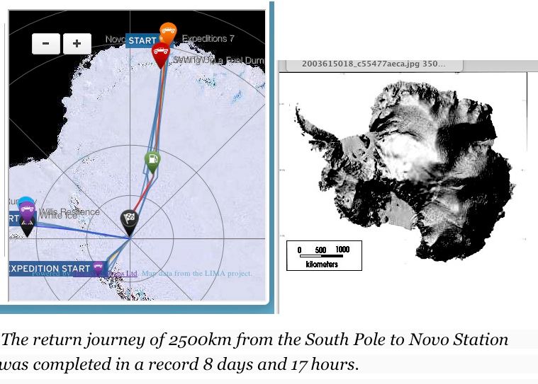
Sure it was. They landed on the moon too. And 9/11 hijackers used boxcutters and brought down the trade centers by crashing planes into them. Yup. It's all true-- if you're willing to believe it to be true. Them Toyota 4 Wheel Drive veeHickles went up and down over the ice and snow of the most trecherous and coldest terrain on the planet... and back again-- several times-- without incident. Yup. Uh huh.
- More comments from Felix: [archive.is/PvL77#selection-923.0-931.23] [archive.is/PvL77#selection-1055.0-1063.23] [archive.is/PvL77#selection-1149.0-1157.24]
- [archive.is/mpR1t]:

- [archive.is/aDRPu]:


* Antarctic Treaty System (en.wikipedia.org) [archive.is/wltrv]

* "Antarctica Mysteries" (marsanomalyresearch.com), page 1 [archive.fo/zKLCH], page 2 [archive.fo/BP5D5], pg. 3 [archive.fo/dfqfq], showing evidence of an actual cover-up of Antarctic terrain except for a rare patch at Bunger Hills, discovered 1947 during an action commanded by Navy Lieutenant David E. Bunger for Operation Highjump, whose lead commander Admiral Byrd described the area as "one of the most remarkable regions on Earth. An island suitable for life had been found in a universe of death." A station was established there by the USSR in 1956, named "Oazis", and in 1959 the establishment was granted to the People's Republic of Poland and was renamed the A. B. Dobrowolski Polar Station [archive.is/GWkPa]. Such as it is, the use of satellites to map Antarctica would secure detailed maps for public knowledge as promised by Google Maps, yet no such maps exist for public view. Among the largest bodies of fresh water in the Bunger Hills area include Algae Lake (Lake Figurnoye), measuring around 16 miles (25 km) long and up to 449 feet (137) meters deep. Another Google Earth photo showing lakes [archive.is/CrceW]
A composite map of satellite images (geology.com) [archive.is/9OmA8]
* "The South Pole Does Not Exist!" [youtu.be/LZP_VZ_Ehvk]

* Continental distribution of certain animal species: Polar Bears, Gorillas, Toucans, and Penguins, map originally posted at [archive.is/qh8bN]:

* Full size [archive.is/FaVeJ]. Coordinates are based on the current location of the north geomagnetic pole (72.62°W 80.31°N) [archive.is/iESLK]


* "Operations Hardtack and Fishbowl; High-altitude Electro Magnetic Pulse Primer; High Altitude Nuclear Test Multimedia and Imagery" (2012, by Dr Carlo Kopp, ausairpower.net) [archive.is/oHcMG]


===*===*===
Sun & Moon on a flat plane -
* "Is the Earth flat?" interview with Eric Dubay, pg. 1 [archive.is/qsXvd], pg. 2 [archive.is/P6hUz]


* "The strange Cook pine trees that always lean towards the equator" (2017-06-02, newscientist.com/article/2133476-the-strange-cook-pine-trees-that-always-lean-towards-the-equator/) [archive.fo/5IrXQ]


===*===*===
Flat Earth Horizon
* "It seemed a flat disc with an upturned edge", quote ascribed to Auguste Piccard, (1931-08, Popular Science magazine, pg. 23), (cover image) (coverbrowser.com/covers/popular-science/3) [archive.is/6nYKo#selection-528.0-535.29], excerpts (imgur.com/gallery/miXLb) [archive.is/q05du], full article (books.google.com/books?id=BCgDAAAAMBAJ&lpg=PP1&pg=PA23#v=onepage&q&f=true), describing the horizon after making an ascent of 10 miles into the atmosphere, an event also detailed at (1931-05-29, Chicago Tribune) (http://web.archive.org/web/20161126230708/http://archives.chicagotribune.com/1931/05/29/page/1/article/fly-10-miles-high-tell-story).
Another meme (banjohollow.files.wordpress.com/2016/06/piccard5.jpg?w=640) [archive.is/hC77f].


* "The Felix Baumgartner / Red Bull 'Stratos Jump From Space' Deception" (2016-01-28, whotfetw.com) [archive.is/2edC5], attached video [youtube.com/watch?v=U1kz-sqO8qI]
* Earth was flat in view from a height of 108,000 feet [youtu.be/ekPc6xT4lUw]
* "DIY space exploration: Family launches GoPro into stratosphere, captures amazing footage" (2017-09-30, rt.com) [archive.fo/QY7tG], video [youtube.com/watch?v=StuWkxYcuko]

Image as from NASA compared to image corrected as from a regular camera


* "Extreme flyby: Weather balloon has close call with Delta Airbus" (2017-06-13, rt.com) [archive.fo/4LFSI], video excerpt showing the warped effect against the horizon that occurs without a corrected lens.


* Fig. 5-7. Crustal thickening in the Himalayan Mountains and Tibetan Plateau is illustrated in this photograph from space. (NASA), posted at [archive.is/biQyr]:

* "Mount Qomolangma & Mount Everest" photo attached to "Weiqi or Go? The art of name translation war" (2017-05-29, news.cgtn.com) [archive.fo/gbzlw] & "Hiking enthusiasts have to know the modern Chinese mountain climbing event" (2016-07-18, ifenglife.com) [archive.is/rsPJk], showing a flat horizon.


Russia Today News (rt.com) is a state media agency of the Federation of Russia, which cooperates with the areo-space agencies of that state government, as shown in the following
 * "RT shoots unique 360 video of MiG jet penetrating stratosphere at 2,000kph" (2016-11-18, rt.com) [archive.is/kKOBx], video page [archive.is/QPdSq], video [is.gd/D4n2Av].
* "RT’s first-ever 360° video from space allows viewers to feel like ‘real cosmonauts’ " (2016-11-18, rt.com) [archive.is/vt9MP]. Video page [archive.is/fvbGn]: 'For the first time in history, we’re filming a panoramic video from the station. It means you’ll see everything we see here, with your own eyes. That’s to say, you’ll be able to feel like real cosmonauts' - Borisenko to RT. Video presented by RT in collaboration with the Russian space agency Roscosmos and the rocket and space corporation Energia. [end article]
Video [is.gd/QmACCA], presented in a distorted format intended for proprietary media technologies used by the RT.com news agency, full video page [space360.rt.com], screenshots of video in its intended view:


* " ‘The Earth is flat’: RT’s ‘Space 360’ leads to age old conspiracy accusations" (2016-11-27, rt.com) [archive.is/0jjEm]: There's a lot of discussion around "fake news" at the moment, but it seems RT has found itself in the middle of a different type of "fakery." RT's Space 360 project has been accused of being faked. Why? Because the "Earth is flat," apparently.
Such accusations were leveled after cosmonaut Andrey Borisenko said that the Earth was round during one the 360° video documentaries, which were recorded on the International Space Station (ISS), in collaboration with RT.
“You can see from here that the Earth is round – no elephants or whales holding it up,” he said, commencing a tirade of accusations, including “BS! Why use a fisheye lens to show convince people that the earth is round.that camera is twisting and turning everything in front of it. I personally don't think that anyone believes this BS.”
Others hit out at the opening of each clip which shows the ISS orbiting the Earth, accusing it of being fabricated on a computer. For once the conspiracy theorists are right, kinda, because this isn’t actually a conspiracy.
The opening footage is actually computer generated, as it depicts a short clip that would be next to impossible to recreate, even with today’s camera technology.
Some viewers believed, however, that RT were trying to portray these shots as 100 percent real, commenting “I think the CGI at the beginning says it all really. An insult to humanity's intelligence.”
“LOL LOL!!!!! Poor CGI even 'Gravity' the Hollywood movie seemed more real! Pathetic, proving again and again the Fraudulent NAZA [sic] and the points made by the Flat Earth awakening movement that we are not in space!“ another commenter said.
A number of viewers have asked if a space walk will be filmed using the 360 video in order to help verify that the cosmonauts are actually in space and not a Hollywood studio. RT hopes to be able to do this in the future, but for now this isn’t something we have scheduled. Don't worry though, there will still be plenty of other videos to watch.
We can safely say that everything else viewers see after the intro is real. We’ll have to take the cosmonaut’s word for it but we also are happy enough that the Earth is round too. Our apologies to those thinking they had just blown the lid on one of the best kept secrets of our time.
For now, put your mind at ease and enjoy RT’s pioneering project which puts viewers inside the ISS, a safe distance from the lizard people back on Earth.
* "MiG-29 Edge of Space Flight" (2016-11-13, World Airlines channel via Youtube.com) [archive.is/yeYRU], video [is.gd/n1vnTr]:
Probably the mightiest experience in the world: The Edge of Space flight in the MiG-29 Fulcrum. Depending on weather and temperature conditions, you can reach up to 20-22km altitude, though at least 17km is guaranteed. Only astronauts and cosmonauts aboard the ISS will fly higher at this point.
You can clearly see the curvature of the earth. The atmosphere looks like a blue fog, covering the earth far below. Above you the sky turns very dark, sprinkled with innumerous stars. An incredible view which only few people were able to enjoy so far!
Mikoyan MiG-29UB Fulcrum "Edge of Space" flight - to the stratosphere. Watch the contrails from 12:40!
Credit to: #MiGFlug
Outside Videos by Artur Sarkisyan
Learn more: (migflug.com) [archive.is/wWMbc]
This outside mounted camera filmed the whole flight.
Unfortunately that day was in early fall and rather warm, more than 15° C. So the jet couldn't climb that high as it usually does, 20km. Remember, Edge of Space flights are best in winter when the air is cold.
* "Journey To The Edge Of Space (360 Video)" (2016-09-22, via Seeker VR Channel, at youtube.com) [archive.is/8J8gb], video [is.gd/89qv0V]: Experience what it’s like to leave Earth, traveling to over 90,000 feet (17 miles) into the stratosphere. Never before has a 360 video been recorded at these heights – so buckle up and enjoy the view as Seeker takes you on a journey to the Edge of Space.


* "Flat Earth Follies: High Altitude Balloon footage PROVES Flat Earth" [archive.is/CwhmL]
* "Derivatives and Definition of a Linear Aircraft Model" report documentation page (1988-08, by Eugene I. Duke, Robert F. Astoaiewicz, and Keith D. Krambers, NASA - Ames Research Center; Published by NASA - Langley) [archive.is/VkWwj]:
This report documents the derivatives and definitions of a linear aircraft model for a rigid aircraft of constant mass flying over a flat nonrotating earth. The derivatives make no assumption of reference trajectory or vehicle symmetry. The linear systems equation are derived and evaluated along a general trajectory and include both aircraft dynamics and observation variables. Key Words (suggested by authors): Aircraft models; Flight controls; Slight dynamics; Linear models.
Reference Publication 11-1391, for sale by the National Technical Information Service
Distribution Summary: Unlimited, Subject Category 08
Security: Unlimited / Unclassified
===*===*===
False Space -
* "NASA’s “Blue Marble” Earth is a fake" [archive.is/WMMOQ]


* "The guy who created the iPhone’s Earth image explains why he needed to fake it" (2014-03-27, qz.com/192700/the-guy-who-created-iphones-earth-image-explains-why-he-needed-to-fake-it/) [archive.is/7x7nO]


* CGI Earth imaging [twitter.com/himawari8bot], unofficial; imagery courtesy: Japan Meteorological Agency (jma.go.jp/en/gms) and CIRA [rammb.cira.colostate.edu/ramsdis/online/himawari-8.asp].
* "WeChat changes launch image photo taken by the Chinese newest satellite" (2017-09-26, cgtn.com) [archive.fo/dHWBO]
* "Earth-Shattering News: WeChat start-up page gets change of scenery" (2017-09-25, broadcast transcript, cgtn.com) [archive.fo/F40E1]: A big change of scenery for the 900 million WeChat users. From Monday through Thursday, the well-known start-up page for the popular messaging app will change. For the past six years, the page has shown the famous man's-first-look-at-the-earth image from NASA. That is shifting to an image taken by China's very own meteorological satellite, the FY-4, WeChat's image of earth also will change, to show a view of China. The satellite went into full operation on Monday, after being launched in December.


* "Freemasons in Space" (aplanetruth.info) [archive.is/9hAp9], in reference to a society whose membership was allowed the privilege of "planting their flag on the Moon", a privilege granted by NASA to no other society, governance, or national entity! The flag used was for the Mother Jurisdiction of the Scottish Rite, whose origin lay within the great State of South Carolina, and whose founders took an expressed interest in the study of the Hebrew language and Biblical lore, alongside other topics, for the purpose of encoding public displays of "secret" knowledge.


* "Are the crew members of 1986 Space Shuttle Challenger still alive?" (2015-04-30) [archive.is/qjWYW]
* "Where On Earth Are NASA’s Rovers Sending Pictures From? Devon Island, Canada" (anonews.co) [archive.is/ERwTe]
* "Satellites Don't Exist" part 1 [archive.is/gLBiK] [begin excerpt]:
 As my research as indicated there are a plethora of platforms that can mimic satellite utility, so lets review.
1. Land-based technologies. Loran (long range navigation)
2. GPS uses Cel-tower triangulation not Satellites
3. High Altitude Airships (HAA)
4. High Altitude Platforms (HAP)
5. Lighter-than-air vehicles (LAV)
6. High Altitude Long Endurance (HALE)
7. High Altitude Long Operation (HALO)
8. StratSat
9. Airborne Relay Communication (ARC)
10. HeliPlat which connects to the HeliNet System
11. High Altitude Shuttle System (HASS)
12. Small Balloon Systems (SBS)
13. Nano Balloon Systems (NBS)
14. Google Loon System
 15. Stratospheric Platform Systems (SPS)
16. High Altitude Long Endurance Demonstrator (HALE-D)
17. Undersea Cable
18. DARPA Integrated Sensor is Structure or ISIS
So as you see there are at least 18 platforms that can be used independently, in tandem or groups to provide all the services that satellites provide. The most glaring aspect of satellite fakery is cost. All 18 platforms I've mentioned are substantially more cost-efficient than satellites and inherently more reliable. It makes no sense to continually risk hurling satellites into space if more cost-efficient, reliable and readily maintainable terrestrial systems already exist, which they do.
 Based on the previous five frauds revealed in part 1, the dubious existence of satellites is even more definitive since NASA cannot furnish a single actual photo or video footage of real satellites. [end excerpt]
* "There are NO REAL Photos of Earth or Satellites in Space!" [youtube.com/watch?v=rxHSbvOG2Gg]
* "Why are photos of satellites most often computer generated?" [archive.is/Za1RZ], an open source question-and-answer forum
* The only "genuine" photo of satellites in place [archive.is/pQ1h2]
* " ‘Catastrophic avalanche of collisions’: Space junk can destroy satellites, scientists say" (2017-05-31, rt.com) [archive.fo/AqAbl] [begin excerpt]: At least 170 million pieces of rapidly-moving space junk are now circulating in Earth’s orbit and this debris may even lead to a “catastrophic avalanche of collisions” and destroy all working satellites and even threaten economies, scientists said.
“The space junk problem has been getting worse every year,” head of Australia's Space Environment Research Centre, Ben Greene, told AFP [archive.fo/5fsa4].
Some 170 million pieces of debris or ‘space junk’ are currently orbiting Earth and only 22,000 are tracked, said Greene, who’s currently hosting a conference among international space scientists in Canberra.
“We're losing three or four satellites a year now to space debris collision. We're very close, NASA estimates, of within five to 10 years of losing everything,” Greene said, adding that “a catastrophic avalanche of collisions which could quickly destroy all orbiting satellites is now possible.” [end excerpt]


* "Flat Earth - The real Venus above the flat plane" [youtube.com/watch?v=Jp1TxJhHpZQ]


Is this the only photograph at this height above Terra Firma showing Luna? Attached to "Stunning images captured by Chinese satellites in space" (2017-04-29, news.xinhuanet.com) [archive.is/sVz9M]

===*===*===
False Curvature -
* "Architects & Engineers for Flat Earth Truth" [archive.is/AmsTj] [begin excerpt]:
 Surveyors, engineers and architects are never required to factor the supposed curvature of the Earth into their projects, providing another proof the world is a plane, not a planet. Canals and railways, for example, are always cut and laid horizontally, often over hundreds of miles, without any allowance for curvature.
One surveyor, Mr. T. Westwood, wrote into the January, 1896 “Earth Review” magazine stating that, “In leveling, I work from Ordinance marks, or canal levels, to get the height above sea level. The puzzle to me used to be, that over several miles each level was and is treated throughout its whole length as the same level from end to end; not the least allowance being made for curvature. One of the civil engineers in this district, after some amount of argument on each side as to the reason why no allowance for curvature was made, said he did not believe anybody would know the shape of the earth in this life.”
Another Surveyor and Engineer of thirty years wrote to the Birmingham Weekly Mercury, Feb. 15th, 1890 stating, “I am thoroughly acquainted with the theory and practice of civil engineering. However bigoted some of our professors may be in the theory of surveying according to the prescribed rules, yet it is well known amongst us that such theoretical measurements are INCAPABLE OF ANY PRACTICAL ILLUSTRATION. All our locomotives are designed to run on what may be regarded as TRUE LEVELS or FLATS. There are, of course, partial inclines or gradients here and there, but they are always accurately defined and must be carefully traversed. But anything approaching to eight inches in the mile, increasing as the square of the distance, COULD NOT BE WORKED BY ANY ENGINE THAT WAS EVER YET CONSTRUCTED. Taking one station with another all over England and Scotland, it may be stated that all the platforms are ON THE SAME RELATIVE LEVEL. The distance between Eastern and Western coasts of England may be set down as 300 miles. If the prescribed curvature was indeed as represented, the central stations at Rugby or Warwick ought to be close upon three miles higher than a chord drawn from the two extremities. If such was the case there is not a driver or stoker within the Kingdom that would be found to take charge of the train. We can only laugh at those of your readers who seriously give us credit for such venturesome exploits, as running trains round spherical curves. Horizontal curves on levels are dangerous enough, vertical curves would be a thousand times worse, and with our rolling stock constructed as at present physically impossible.”
Engineer, W. Winckler, wrote into the Earth Review October 1893 regarding the Earth’s supposed curvature, stating, “As an engineer of many years standing, I saw that this absurd allowance is only permitted in school books. No engineer would dream of allowing anything of the kind. I have projected many miles of railways and many more of canals and the allowance has not even been thought of, much less allowed for. This allowance for curvature means this - that it is 8” for the first mile of a canal, and increasing at the ratio by the square of the distance in miles; thus a small navigable canal for boats, say 30 miles long, will have, by the above rule an allowance for curvature of 600 feet. Think of that and then please credit engineers as not being quite such fools. Nothing of the sort is allowed. We no more think of allowing 600 feet for a line of 30 miles of railway or canal, than of wasting our time trying to square the circle”


===*===*===
The Firmament & the Celestial Dome!


===*===*===
RAW DATA
[http://www.flat-earther.co.uk]
[archive.is/MOZX1] [archive.is/sVBUx] [archive.is/fKk9s]
The Atlantean Conspiracy By Eric Dubay (.pdf) [https://ia802504.us.archive.org/30/items/Atlantean_Conspiracy/the_atlantean_conspiracy__final_edition_.pdf]
Babylonian View of the Cosmos [archive.is/ZL5rP]
Biblical views of the Cosmos [archive.is/bx5DO] [archive.is/omKQu]
Rare FLAT EARTH Manuscript : FLUDDS Meteorologia Cosmica [https://www.youtube.com/watch?v=RsJnG3WB8nA], intro [archive.is/67w33]
1500s: They cam from outside the firmament, traveled by uranium engine with uranium front-armor, pierced the veil, the onrush of the melted water capped by the re-freezing... and lo, did appear the Milky Way, and strangers in our midst!
* "First Airplane Flight Over Antarctica" (2012-02-17, royalaviationmuseum.com) [archive.is/ENUS8]:
 In early December 1935, two men flew over the last unexplored area on earth – the Antarctic. One of them was the American world-famous explorer Lincoln Ellsworth and the other was Herbert Hollick-Kenyon, a Canadian Airways Ltd. pilot based in Winnipeg. Among his qualifications, Hollick-Kenyon had experience in the ‘specialized art’ of starting airplane engines in cold weather and had played a leading role in search for the marooned 1929 MacAlpine expedition.
 It was Ellsworth’s third attempt to fly across the Antarctic. The plane was the Northrop Gamma, the first plane to be built by the newly formed Northup Corporation of California. It was an all-metal, low-wing monoplane powered by a Pratt & Whitney 600 hp radial engine. Its top speed was rated at 230 mph with a cruising radius of 7,000 miles fully fuelled.
Ellsworth and his team sailed to Dundee Island opposite the tip of South America in late 1935. By November 18, the Polar Star was re-assembled, test-flown and ready.
On November 21, with full fuel tanks and three months of emergency rations, Hollick-Kenyon lifted the Polar Star’s 7,600 pounds into the air. Ninety minutes later, they aborted the flight because the glass fuel flow gauge was cracked and likely to burst. They took off the next day, and again aborted the flight, this time due to bad weather.
On November 23, Ellsworth and Hollick- Kenyon took off for the third time. After several hours they lost radio contact with their base and landed after flying 13 hours.
On November 24th, they resumed their journey, but only for another 30 minutes when the weather forced them to land, stranding them for the next three days.
In the afternoon of November 27, Ellsworth and Hollick-Kenyon took off but weather forced them to land after 50 minutes. Another blizzard grounded them a further three days. They were, however, able to determine that they were about 500 miles short of their goal. When the storm ended, it took three days to dig out the Polar Star. The engine fired up in the afternoon of December 3, but they did not take off because still another storm moved in.
Able to fly on December 4, they were airborne for about four hours and landed to check their position and fuel supply.
They took off for the last time only to land an hour later when Polar Star’s engine sputtered and died – they were out of fuel.
Dead reckoning told them they were close to their destination, Little America. But, they didn’t know in which direction.
It took another 11 days, until December 15, for Ellsworth and Hollick-Kenyon to get their bearings and travel the remaining distance, which turned out to be a mere 16 miles. (Navigation depended on accurate sextant readings, something which eluded the pair until they discovered a loose adjusting screw in their instrument.)
The rescue plan consisted of a directive to look for them along the coastline in the vicinity of their destination, Little America, and to continue the search for a set period of time. They were sighted by the British Research Society ship Discovery II on January 15, 1936.
Ellsworth donated the Polar Star to the Smithsonian Institute. Although many international honours were showered on Ellsworth in the wake of the Antarctic adventure, Hollick- Kenyon was not entirely forgotten – one of his many honours was a knighthood, becoming Sir Herbert Hollick-Kenyon. He retired from Canadian Pacific in 1962 and was named to Canada’s Aviation Hall of Fame in 1973. It was also reported that at one point Hollick-Kenyon also operated a motel in British Columbia where few, if any, travellers knew of his adventures. Hollick-Kenyon died at age 78 in 1975 in Vancouver.
A successful polar crossing was not repeated until 1956. The combined achievement of Lincoln Ellsworth and Herbert Hollick-Kenyon is properly recorded as one of the greatest flights in early aviation history.


No comments:
Post a Comment