Theoretical identities of Nations part of the modern perception of the "Mongol Empire", at the time of the "Heinsohn Horizon" (230s=520s=930s AD) will be included on this page as evidence permits. As much as possible, eastern Eurasia source materials will be given precedence over the European consensual narrative for the history of the "Mongol Empire".
The difference between a Slav, a Tartar, and a "western European" was, simply, to what authority their kings, or Khans, adhered to.
- The "western European" was ruled by kings adhering to the Bishop of Rome.
- The Slavs were ruled by kings who adhere to the Patriarch of Constantinople.
- The Tatars, or Turks, were labeled as such by the map makers of "western Europe" to classify their status as adhering to neither the Bishop of Rome nor the Patriarch of Constantinople, and included all Khans who adhered to Quranic authorities, or Buddhist authorities.
and
- The Khazarians of 700s AD through 1100s AD were "Turks" who adhered to a council of Talmud scholarly authorities in Baghdad (?), or, simply, "Jewish". A question apart is if the scholars of Khazaria interacted with, or had a schism with, their counterparts in "western Europe" at the "Sephardi" councils of scholars, and if the latter community also adhered to the Talmud authorities in Baghdad on a hierarchal basis or, contrary, as equals.
and, finally
- The Turks of modern Turkey in Anatolia peninsula, and the "Turks" in central Asia represented by the modern republics of Chechnya, Dagestan, Kazakhstan, Uzbekistan, et al. are
For example, the Federation of Russia (specifically "European Russia") is a continuation of the Moscow "Metropolitan State" (for lack of terminology) which is clearly identified on maps from "western Europe" of the 1500s AD, described in "Falsification of history as a kind of war of aggression" [archive.is/Q7O8Y], an article that shows how maps were created that falsifies the history of the expansion of the Moscow "Metropolitan State".
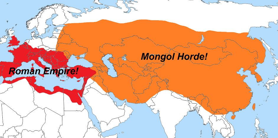
Alongside and before the Moscow "Metropolitan State" is the "Golden Horde", which, according to the consensually accepted narrative, is a continuation of the "Mongol Empire", and the lands they are known to inhabit are shown on maps as "Tartary" (and variations of the geographic title) produced in the Roman realms beginning during the 1500s. Tartary may be the area where there are no Roman establishments like a monastery or trade zone, and... or... it is a unified "state" which is united by the Buddhist faith with two centers of government (in Lhasa within modern Tibet, and Ulan Bator in modern Mongolia) among whose realm exist a peaceful co-existence with Muslims and Christians (this is the historical "Pax-Yuan" before the "Black Death" of the 1360s AD).
* (by Alexey Pleshanov, fund.cyrillitsa.ru) (machine translated) [archive.is/exdNX] [begin excerpt]: The Motherland has no children's photos. This role is played by the ancient maps that captured her first steps in this world. Russian cartography appeared relatively late, so we can judge the first moments of Moscow Rus solely from the atlases of European cartographers. From this, contemplation acquires additional intrigue and depth. [end excerpt]
Sections include:
* Exposition 1: Eurasia before the "Pax-Yuan"
- 1.1: "Russia" before the "Pax-Yuan"
- 1.2: Koryo (Corea) before the "Pax-Yuan"
* Exposition 2: "Pax-Yuan", a hypothetical layout, 1200s through 1300s AD (800 to 601 years BM)
* Exposition 3: Eurasia after the "Pax Yuan", by century
Exposition 1.1:
"Russia" before the "Pax-Yuan" -
* "…to the Maeotic Lake on the east, where it bordered on Pontic Scythia, and that from that point on Gauls and Scythians were mingled". (Plutarch, Mar. 11:4-5)
* "GALLO-SCYTHIANS - Celtic Ukraine" (.pdf) [is.gd/SNJEeD] [begin excerpt]: Major finds of Celtic coinage in Western Ukraine have been registered at the Gut and Mala Kopanya sites. In the occupation layers at the Celtic settlement at Gut (Garazdivka, Beregivs’ kyj district) over 100 Celtic coins of the ‘’Philip II type’’ were discovered in a ceramic vessel, among them examples of the Huşi-Vorieşti type attributed to the Celto-Scythian Bastarnae (see ‘Celtic Coinage from Ukraine’). The latter type have recently been discovered in hoards along with other Celtic coins at sites such as Pelczyska in southern Poland (Rudnicki 2003; See ‘The Celts in Poland’), and the examples from Gut are further evidence of the close political and economic links between the Bastarnae and other Celtic tribes north of the Carpathians. Noteworthy also is the chance discovery of a pottery vessel at Mala Bigan, in the same Beregivs’kyj district, which contained small figurines of a boar and a man, a bronze ankle ring, and a La Têne (C1) glass arm ring (Bidzilya 1971: 21-30; 46; Kazakevich op cit).
At the Mala Kopanya hillfort (Vynogradivs’kyj district), which is situated slightly to the north-east of the aforementioned Celtic settlements at Nove Klynove and Ciumeşti respectively, in addition to a large amount of Celtic material including 7 ritually ‘killed’ late La Têne swords (Kazakevich op cit.) a substantial amount of Celtic coins of the ‘Philip II types’ have been documented.
On the Dneister river, traces of a Celtic speaking population are to be found in several place- and ethnic names, among them Καρρόδουνον, Мαιτώνιον, and Ήρακτον (Claud. Ptol. III.5.15; Sims-Williams 2006: 218-19, Falileyev 2005, 2007:4-9), and the name of the Kamula mountain (Tischenko 2006:220, Kazakevich 2012a: 172). In the vicinity of the latter is situated the Celtic cemetery at Gryniv, notable finds from which include 5 late Le Têne swords, and burial # 3 in which the famous Gryniv scabbard was discovered. A further 2 late La Têne swords have been recorded in a burial at Nyzhnya Stynava (Stryjs’kyj district) in the Lvivs’ka region (Bandrivsky, Josypyshyn 1997: 9-10), also in western Ukraine.
The recent discoveries of a rich Celtic burial complex at Mutyn on the river Seim in the middle Dneister basin has supplemented our knowledge of Celtic settlement in this area of western Ukraine. Excavations in 2009-2010 revealed ‘a dozen’ Celtic warrior burials, dating to the 1st c. BC, containing 13 late La Têne swords, scabbards, spearheads, chainmail, helmets and shield bosses (Kazakevich 2012a).
Also noteworthy are Celtic coins registered in the Dneister Estuary area of Ukraine, most of which originate among the Celtic tribes of today’s northern Bulgaria, indicating strong political and economic links between the Thracian Celts and those in the area of western Ukraine (see ‘Celtic Coinage from Ukraine’). [...]
In this context one should note that the Celto-Scythian Bastarnae continued to be a considerable force in the region. The “Late Bastarnae” are mentioned in the epitaph of Plautius Silvanus from 74-79 AD (CIL XIV 3608), and in the late 2nd century the Historia Augusta mentions that in the rule of Marcus Aurelius (161-80), an alliance of tribes including the Bastarnae, took advantage of the emperor's difficulties on the upper Danube (the Marcomannic Wars) to invade Roman territory (Historia Augusta Marcus Aurelius II.22). They were also among the tribes who participated in the ‘Gothic’ raids between 248 and 269 (Schukin 1999). Thus, for example, in 250-1 the Bastarnae were involved in the Gothic and ‘Sarmatian’ invasions which culminated in the Roman defeat at the Battle of Abritus in north-eastern Bulgaria, and the slaying of the emperor Decius (251) (Herwig 1988: 45-46).
This explains the Celtic element in the Gothic migrations and attacks on Roman territory, a phemonenon which is confirmed by anthropological studies which have identified a Celtic component among the Goths (Rudych 2004:394; Kasakevich 2012b), and La Têne influences in the ‘Gothic’ Cherniakhov culture (Schukin 2005:165). In the later Roman period the policy of Ethnic Engineering also had the long term effect of further complicating the ethnic mix in the region. Under the Emperor Probus (276-82) 100,000 of the Celto-Scythian Bastarnae were settled in Thrace (Historia Augusta Probus 18), and shortly afterwards Emperor Diocletian (284-305) carried out another ‘massive’ transfer of the Bastarnae population to the south of the Danube (Eutropius IX.25; see ‘Ethnic Engineering’). However, these forced migrations would not have consumed the demographic potential of the “great nation”, and the remaining Celto-Scythian population participated in the complicated ethnogenesis of the early medieval peoples, among them the Slavs. [end excerpt]
Maps and photos:
- Main La Têne sites and finds east of the Carpathians (after Kazakevich 2012a):

- Celtic sites and finds from the Upper Tisza Basin (after Kazakevich 2012a):

- The Celtic Montefortino type helmet from Bilen’ke (Bilogorod-Dnistrovs’kyj Regional Museum):

- Boar and human figurines, and Celtic glass arm ring from Mala Bigan (after Kazakevich 2012a):


- Celtic coinage from the Mala Kopanya site. The coins are of a type associated with the Transylvanian Celts. (see Balkancelts ‘Celtic coinage from Ukraine’), photo [archive.is/bgJRx]:

- The Gryniv Scabbard: The Gryniv scabbard was discovered in burial # 3 at the cemetery and dated to between the second and fourth decades of the 1st c. AD. The burial contained an iron fibula, sword/scabbard, spearhead, 3 knives, a spur, shield umbo, pottery of local and Balkan origin, and shears (Kazakevich op cit.). The presence of shears in Celtic burials is well documented among the Celts of central and eastern Europe (see also ‘Kalnovo’ article), and many of the objects in the burial, as at the aforementioned Mala Kopanya site, had been ritually killed – i.e. broken, bent or otherwise deformed, according to the well known Celtic custom (see ‘Killing the Objects’; on the scabbard see also ‘Gryniv Scabbard’ article).

- Novo Mesto type helmet from the river Sava near Stara Gradiška in Croatia. Two of the five Celtic helmets recently discovered at the Mutyn site in western Ukraine are of the Novo Mesto type.
(see ‘Eastern Celtic Helmets’ article):

- Celtic Coins from the Dneister Estuary area (Odesa Museum, Numismatics Collection; Celtic Coinage from Ukraine) CENTRAL/EASTERN:

- Statuettes of Celtic Warriors from the North Pontic Area (after Kazakevich 2012a):

- "The tomb of Skilurus": Skilurus ruled over the Tauri and controlled the ancient trade emporium of Pontic Olbia, where he minted coins. In order to gain advantage against Chersonesos, he allied himself with the Rhoxolani, whom Strabo (VII:3) states were the most northern of the Celto-Scythian Bastarnae tribes. In response, Chersonesos forged an alliance with Mithridates VI of Pontus (on whom see below). Skilurus died during a war against Mithridates VI, a decisive conflict for supremacy in the Pontic steppe. Either Skilurus or his son and successor Palacus were buried in a mausoleum at Scythian Neapolis, which was used from ca. 100 BC to ca. 100 AD.
Scythian_Neapolis_Mausoleum

- Kingdom of Pontos, Mithradates VI AV Stater. Pergamon mint, (88/7 BC):

* "Myths of Russian History: Does the word 'Slavs' derive from the 'slave'? While western researchers carelessly tend to equate the word “Slavs” and “slaves,“ modern Russian linguistic scholars and historians are finding new information and historical facts that challenge such long-held claims. Starting with this article, RBTH launches the series Myths of Russian History" (2017-07-17, rbth.com) [archive.fo/9fMKD] [begin excerpt]:
During the time of Slavic expansion, they attacked the Byzantium Empire in the Balkans, destroyed Greek places and took inhabitants as slaves. Historians, such as the famous Soviet and Russian researcher Igor Froyanov, emphasized that many slaves were taken by the Slavs. As shown in sources mentioned by the historian [archive.fo/6aG2G], the slaves of this era in this part of the world were mainly Greek.
According to the prominent Byzantine historian Procopius of Caesarea, every year starting from the early period of Emperor Justinian’s reign (527 AD), the Slavs raided and took many captives and turned the land into a “Scythian desert.” Greek writers depicted the Slavs as those “who cannot be forced into slavery or subjugated in their own country” [archive.fo/MNkHu]. Hence, it might be hard to imagine how the word “Slav” originated from “slaves.”
Simply homonyms?
One starts to wonder how then to explain this similarity of “Slav” and “slave” in Byzantine Greek? One explanation is that the two are just homonyms; they sound similar but have different meanings. But then, where does the Greek “slave” come from? It is argued that it originated in the word for plunder or taking war booty (skyleuein).
At the same, it’s worth pointing out there’s no consensus on the issue of the etymology of “Slav” [archive.fo/Y0xLs]. Some time ago there was a popular theory according to which the word derived from slava, “glory.” This was a Slavic reaction to the “slave approach,” but the majority of historians do not accept this.
In fact, the most popular version sees “Slavs” as deriving from slovo, “word,” (meaning “people who can speak our way”). There are also historians who tie the etymology of “Slavs” to the ancient Indo-European word, slauos, which meant, “people.” [end excerpt]
* "Byzantium" (retrieved 2015-10-26, en.wikipedia.org) [archive.is/Yl1I2] [begin excerpt]: Much later, the name Byzantium became common in the West to refer to the Eastern Roman Empire, the "Byzantine" Empire, whose capital Constantinople stood on the site of ancient Byzantium. This usage was introduced only in 1555 by the German historian Hieronymus Wolf, a century after the empire had ceased to exist. During the time of the empire, the term Byzantium was restricted to just the city, rather than the empire that it ruled. [...]
Though associated with the Sassanid Persians and with Mithradates VI Eupator (who for a time incorporated the city into his empire), by the late Hellenistic or early Roman period, the star and crescent motif had been associated to some degree with Byzantium. For example, some Byzantine coins of the 1st century BC and later show the head of Artemis with bow and quiver, and feature a crescent with what appears to be a six-rayed star on the reverse. According to accounts which vary in some of the details, in 340 BC the Byzantines and their allies the Athenians were under siege by the troops of Philip of Macedon. On a particularly dark and wet night Philip attempted a surprise attack but was thwarted by the appearance of a bright light in the sky. This light is occasionally described by subsequent interpreters as a meteor, sometimes as the moon, and some accounts also mention the barking of dogs. However, the original accounts mention only a light in the sky, without specifying the moon. To commemorate the event the Byzantines erected a statue of Hecate lampadephoros (light-bearer or bringer). This story survived in the works of Hesychius of Miletus, who in all probability lived in the time of Justinian I. His works survive only in fragments preserved in Photius and the tenth century lexicographer Suidas. The tale is also related by Stephanus of Byzantium, and Eustathius. [end excerpt]
* "Mercenaries in Ancient Rus’: Why Russians weren’t afraid of the Vikings; The rulers of ancient and medieval Rus’ eagerly sought assistance from mercenaries, be they Scandinavian warriors or fighters from nomadic steppe tribes. The relationship between the state and mercenaries was often strained. Nevertheless, in the end the mercenaries were generally incorporated into the ever-changing social fabric of the Russian state" (2017-10-10, rbth.com) [archive.fo/d2etY]
* "Where Mud Is Archaeological Gold, Russian History Grew on Trees" (2014-10-18, nytimes.com) [archive.is/MUdH7] [begin excerpt]:
In an interview in his office, the city’s mayor, Yuri I. Bobryshev, glowed with pride as he described its history as a major trading post of the medieval Hanseatic League, with strong ties to the European centers of Lubeck, Bruges, Ghent and London.
“It was a union of merchants and the decisions taken by that union were unconditionally carried out by the rulers of all European states,” Mr. Bobryshev said, adding with a sly smile, “Of course, at that time there was no trace of the United States.”
He then boasted about Novgorod’s role, along with Kiev, as one of the two principal cities of Kievan Rus — the original Russian Federation — adding that Moscow could lay no claim to national prominence until Ivan III made it the capital in the 15th century.
“That’s why we speak of Novgorod as the motherland of Russia,” Mr. Bobryshev said. “In Novgorod, the first customs office appeared. The ruble appeared in Novgorod. The first school was in Novgorod, in 1030 by Yaroslav the Wise, our Novgorod prince. It was founded not only for the children from rich families, but for everyone. So Novgoroders were absolutely literate people in the Middle Ages.” [end excerpt]
* "Ancient Roman coin found in Russian Novgorod by archeologists; Archeologists have found a Roman coin during excavations in the historic center of the northern city of Veliky Novgorod, an archeologist said on Monday" (2014-06-30, sputniknews.com) [archive.is/SvQBC]:
The copper coin, which belongs to a type known as "follis," is believed to date to the early 4th century A. D., Oleg Oleinikov of the Moscow-based Archeology Institute of the Russian Academy of Sciences, told Interfax.
Oleinikov said it was the first such artifact to be found in Veliky Novgorod. It lay in the early-11th-century occupation earth layer, Oleinikov said.
The coin was believed to have been minted during the reign of Emperor Constantine I, founder of Constantinople. There is a picture of the goddess Roma and a Latin inscription saying "City of Rome" on the obverse and a picture of the Capitoline Wolf with Romulus and Remus on the obverse.
Oleinikov said the follis, which was a little more than one centimeter in diameter, was well-preserved and that researchers were examining it currently.
"Among other things, we have to find out in what city it was minted," he said.It will most likely remain a mystery how the coin ended up in 11th-century Russia. Oleinikov expressed suspicion it had been brought back from Byzantium by a pilgrim.In those days, pilgrims who brought back coins from their trips had a custom of wearing them round their neck as a memo of what, in those days, would have been such a long journey.
The Veliky Novgorod coin had no hole in it, which suggested its owner had lost it soon after returning to the city. "If that was the case, it would have been a real tragedy - bringing a coin from the other end of the world and losing it immediately," Oleinikov said.
Archeologists have made more than 1,000 remarkable finds during the excavations, which began in mid-May, take up an area of about 300 square meters, and involve digging through a layer of earth about six meters deep. The finds include six Russian birchbark manuscripts and a possibly unique ornament dating to the 14th or 15th century and showing a psaltery player singing to a group of warriors.
* "Coins of the Khazar Empire" (2000, by Glen Shake; pg. 44) [books.google.com/books?id=3jd1Ni0uPVQC&pg=PA44] [archive.is/dKJMg] [begin excerpt]: The adoption of the Roman alphabet closely coincides with the adoption of Christianity and as a consequence it is fair to say that most Viking historical records of the Baltic peoples begins approximately with the beginning of Christianity in their realms.
Coins of the period prior to about 1100 are attributed by historical chronicles, usually written in Latin, as the coins did not have dates on them. The first coins that obtained a continuous dating system were the silver coins from the Islamic rulers beginning when a standard format was adopted by Islamic Cultures to indicate the date. AH 79 converts to AD698, which is at least 400 years before the first date, using the Gregorian calendar, appeared on coins of the European cultures and only infrequently for the next three centuries. [end excerpt]
* "Medieval Moscow Calling: Archaeologists Dig Up Tale of Woe From Middle Ages; The Russian Academy of Sciences carried out archaeological excavation in the historical center of Moscow which found hundreds of items of historical interest, in particular a medieval manuscript written on birch bark" (2015-10-24, sputniknews.com) [archive.is/uaISY]
* "Birch bark letter no. 292" (retrieved 2015-10-26, en.wikipedia.org) [archive.is/0oal5] [begin excerpt]: The birch bark letter given the document number 292 is the oldest known document in any Finnic language. The document is dated to the beginning of the 13th century. It was found in 1957 by a Soviet expedition led by Artemiy Artsikhovsky in the Nerevsky excavation on the left coast side of Novgorod. The language used in the document is thought to be an archaic form of Livvi-Karelian, the language spoken in Olonets Karelia,[2] although the exact form is difficult to determine as Finnic dialects were only developing during that period. [end excerpt]
* "The first birch bark manuscript discovered in Velikiy Novgorod" (1951-07-26, prlib.ru) [archive.is/dcPyL]: On July 26, 1951 at Nerev pit the Novgorod archaeological expedition led by Soviet archaeologist A. V. Artzihovsky discovered the first writing on birch bark which listed different feudal obligations.
The fact of using a birch bark for writing in ancient Russia was known quite a long time ago from the works of medieval authors as well. It was mentioned for example by the church and political personality of the second half of XV century – beginning of XVI century Iosif Volotsky. However up to 1951 only single foreign language texts had been found (writing in English of 1570, the Golden Horde document of XIV century).
The very first ancient Russian birch bark writing – a short letter by commoner who lived in XV century – was found during the excavations in Novgorod. The excavations were undertaken by the expedition of archaeologist A.V. Artzihovsky from 1932 but only in 1951 the archeologists reached Nerevsky region of the city. Right there between the blocks of pavement flooring of ancient of Kholopy street in layers of the end of XIV century on July 26, 1951 a participant of the expedition N.F. Akulova saw a long-awaited piece of a birch bark writing with Russian text. By the end of field season the expedition discovered nine more similar documents.
Later a birch bark writings were discovered during the excavations in Moscow, Pskov, Smolensk, Old Russa, Tver, Torzhok, Vitebsk, Mstislav, Zvenigorod Galitsky. Today their number has exceeded one thousand. The most ancient birch bark writings are dated of the first half of XI century and the most recent ones of the middle of XV century.
Discovering of birch bark writings opened a new page in the study of the Russian language history, expanded the notion of scientist of the life particularities of a medieval person. Unlike ancient Russian annals, the texts of birch bark writings are completed with everyday life details. The most of the writings are letters, but among them could also be found different rolls, edicts, rough copies of documents, study exercises, alphabets, charms, text of religious character. The fact that most of the documents are written in ancient Russian usual language results from everyday life subject area.
Birch bark writings considerably changed traditional ideas about literacy expansion degree in ancient Russia. Among their authors and addressees along with priests, high officials, house owners and merchants there are seniors, stewards, craftsmen, warriors, women, children, etc. In experts’ opinion the cultural layers of Novgorod hide about 20 thousand more birch bark writings of ancient Russia.
* "Novgorod the Great: a look into the past; The 2008 archaeological season is in full swing in the city of Novgorod the Great (Veliky Novgorod) in north-western Russia. The team has already unveiled about 1000 of their findings, including coins, birchbark manuscripts, houseware and a textbook dating back to the 11th century. Archaeologists have been working in the city of Novgorod the Great since 1932" (2008-08-15, sputniknews.com) [archive.is/TyvCj]
* "Birch bark manuscripts; This year Novgorod Veliky (Novgorod the Great in the English translation) turns 1150. In the middle ages it was one of Russia’s wealthiest and culturally advanced towns of Russia: almost all of its population was literate, a fact confirmed by numerous birch bark manuscripts found during archeological excavations" (2009-11-18, sputniknews.com) [archive.is/cVRXv], 2nd version [archive.is/8suQn]
* "Russian archeologists find 1000th birchbark manuscript; Russian archeologists have found the 1000 th birchbark manuscript in Nizhny Novgorod (north west from Moscow). The first manuscript was found in 1951. Now the find is being restored and is to be deciphered. It is supposed to be a letter from two Novgorod men to their relatives" (2010-07-21, sputniknews.com) [archive.is/Nixx9]: 28 birchbark letters have been found in Novgorod since June 17. They prove that ancient Novgorod people were literate and exchanged messages on different occasions.
* "Digging out history" (2010-07-21, rt.com) [archive.is/71hYo]
* "Archeologists find another ancient Novgorodian; Russian archaeologists have discovered this summer 23 birchbark manuscripts in Velikiy Novgorod. According to academician Andrei Zalizniak, who studied these finds, most of them relate to a certain Yakim, who lived in Novgorod at the turn of the XII and XIII centuries" (2010-09-16, sputniknews.com) [archive.is/PnRzx]
* "Lord Novgorod the Great: There is no other city like Novgorod in Russia. By far the oldest Russian city, Novgorod or Veliky Novgorod, its official name, was a key pillar of the emerging Russian statehood. A well-fortified flourishing trade hub in the northwest of the medieval state of Kievan Rus, Novgorod was its second largest city after Kiev" (2011-04-25, sputniknews.com) [archive.is/x5PfJ]
* "The first Russian library: 2012 has been declared a year of Russian history, and in our features we shall be acquainting you with the more noteworthy events in the history of our Homeland" (2012-04-05, sputniknews.com) [archive.is/jbP1F]
* "Medieval SHOPPING LIST found in Russia: 14th century document among dozens of birch bark scrolls discovered in ancient city; Dozens of writings from the 14th century have been found in Russia; The birch-bark documents were found in the ancient city of Novgorod; One is a shopping list written from a father to his son; Others include business transactions and accusations of crime; All were written on tree bark and have been preserved in mud for centuries; The findings provide insight into an important city of Russian history" (2014-10-22, dailymail.co.uk) [archive.is/1qPmM]
* "Russia: the exploration and development of the Arctic: Researchers claim the advance of East Slavs towards the European North dates back to the 6th century A.D. The development of areas within the Arctic Circle was certainly prompted by perfectly material reasons, above all the huge mineral resources of these lands. As early as the 10th century A.D." (2007-08-07, sputniknews.com) [archive.is/IPaq1]
* "Russian woman: forever ideal" (2012-08-07, sputniknews.com) [archive.is/mjO3K]
Initial reports erroneously stated the cities were dated to 8000 years BM, instead, the following are dated to being constructed 2600 years BM...
* "NASA releases images of enormous 8,000-year-old patterns" (2015-10-30, rt.com) [archive.is/N2jrp]
* "Mysterious Geoglyphs in Northern Kazakhstan Get a Boost from NASA; NASA has uploaded satellite images of ancient earthworks that were discovered by a Kazakh archaeologist" (2015-10-31, sputniknews.com) [archive.is/CHv7p]
* "Turgay Trough Geoglyphs" lecture slides (2015-09-09, by Dmitriy Dey, pitt.edu) [http://is.gd/DaGycG], some interesting slides [http://is.gd/kR2cez], [http://is.gd/XcdNVL]

* [archive.is/BYs0R]: There is a unique object on the South of Ukraine. Ages ago this place was just a bottom of Pontus sea, later on the sea went away and left a dessert here, and lastly, the place of stones' and limestone's accumulation became a pagan altar when people came. Nowadays it's a mysterious and little-known reserve. There are more than 50 grottoes and caves, and several thousands petroglyphs, also knows as rock art. Here is the image of birdview of the altar.
1100s - 1200s AD (701 to 900 years BM)
* "Archeologists unearth Moscow’s oldest street" (2015-09-23, rt.com) [archive.is/3Ytr9] [begin excerpt]: Scientists digging at the site of a demolished hotel in the heart of Moscow have unearthed the oldest street archeologists have ever had a chance to study, they report. The medieval street connected the Kremlin with the bank of the Moskva River. The find is located in a historic city area called Zaryadye, east of the Kremlin. The name means ‘behind the rows’ and refers to the marketplace that was next to the fortress. Wealthy merchants and warriors lived there and did business. The dig produced a trove of historic artifacts from the medieval times, when Zaryadye was a major trade hub in Moscow, scientists of the Archeology Institute of the Russian Academy of Sciences reported Wednesday. Those include what used to be the street called Velikaya (Great), which led from the Kremlin to a pier on the Moskva River to the south. The 6.5-meter-wide street appeared on the maps during the early stages of the city’s expansion in 12th-13th centuries. The archeologists also discovered several artifacts at the dig site that give a glimpse at how the busy trade district looked centuries ago. One is a fragment of a pilaster from a church or a nobleman’s palace with a distinct ornament. “This ornament belongs to a rare but documented Renaissance form of the Italian architecture. This stone can be linked to the Russo-Italian period of construction, the time when the modern Kremlin walls, its main cathedrals and the great prince palace were created,” said Leonid Belyaev, the head of the Muscovite Rus Department at the institute, who leads the excavation. [end excerpt]
===*===*===
Exposition 1.2:
Koryo (Corea) before the "Pax-Yuan" -
* "World’s earliest inventions by Koreans" (2016-02-28, naenara.com.kp) [archive.is/2WcvO]
Among the cultural assets the Korean people created throughout the history spanning 5 000 years are such world’s first inventions as metal type, rain gauge and turtle-shaped armoured ship.
The people of Koryo (918-1392) who had long employed woodcut succeeded in making wooden type before the early 12th century, saving the labour-consuming process of engraving letters on wood blocks to be used to print books.
Later, the development of metal processing technology made it possible to cast metal type.
Copper types, each 1.1cm X1.0cm in size, which are supposed to have been cast in the early 12th century, were unearthed in a Koryo royal tomb in Kaesong.
The preface of Sangjongryemun, an old book printed in metal type before 1324, says that 28 copies of this 50-volume book were worked off on Kanghwa Island.
Books were printed in metal type in large numbers in the 13th-14th centuries, and a typical book is Jikjisimgyong that was printed in 1377.
The expo History of Books held in Paris, France, in 1972 under the sponsorship of UNESCO confirmed that the book from the Koryo period is the oldest book among the existing ones printed in metal type.
Rain gauge was invented in the 15th century.
Earlier, rainfall was estimated by measuring the depth of soaked soil after rainfall, so measuring differed according to the conditions of soil and topography.
But developing agriculture required scientific measurement of rainfall.
Historical records say that a cylindrical iron rain gauge was developed in 1441, which was about 40 centimetres in height and nearly 16 centimetres in diameter. Similar rain gauges were manufactured in 1442 and 1770 and on several other occasions. The cylindrical container was put on a stand to collect rainwater and measure its amount.
Turtle-shaped armoured ship was devised in the 16th century.
The oval ship was 35 metres long, 11.8 metres wide and 5.2 metres high.
The deck was covered with iron like a submarine to prevent seawater from coming into the ship, and the interior was arranged conveniently for the action of sailors, commanding and issuing of orders.
The armour was covered with spikes and knives to keep enemy troops from coming aboard and there was a narrow path in the shape of a cross.
There were ten oars on each side of the ship, as well as some 70 holes for firing rifles and guns.
The bow was in the shape of a dragon’s head. During battles sulphur and nitre were burnt to send the smoke out in order to make the enemy unable to see the environs clearly.
The ship had two masts in the rear of the deck to gain auxiliary propelling power from the wind and two tails at the stern to keep the balance and regulate the speed for safe and fast sailing.
The folding sail on the deck was also used for additional propulsion.
The ship demonstrated its power in different naval battles including the one in Sachon during the Imjin Patriotic War (1592-1598).
Photo caption: A model of the “Turtle-shaped Armoured Ship” in the Pyongyang Folk Park.

* "Chronicles of the Feudal Joson Dynasty" (2017-04-26) [naenara.com.kp/en/news/?0+101145]:
Chronicles of the Feudal Joson Dynasty is a document recording the historical facts of over 500 years of the feudal Joson dynasty that existed from July 1392 to August 1910. Written in the form of diary, it is the greatest of its kind in the world.
The original texts are of 1 763 books and the number of volumes are nearly 900.
It not only records domestic and foreign policies concerning politics, the economy, culture and military affairs but also comprehends music, dance, fine arts, handicraft, and such natural subjects as astronomy, weather conditions, earthquake and tidal waves.
As it records without missing even a day the detailed events that took place in the country for over 500 years, it constitutes a very precious wealth in studying the astronomical and meteorological data as well as the policies and history of the government.
* "Educational System of Feudal Joson Dynasty" (2017-01-22, naenara.com.kp) [archive.is/uMDRR]:
Confucian school or study, local school annexed to the Confucian shrine and Songgyungwan university existed in the days of the feudal Joson dynasty as educational institutions.
As a private educational institution similar to primary school in the present days, the Confucian school had been established with villages as the unit.
The students enter the school at the age of 7-8 and graduated from it at 15-16. They were educated in reading, writing and composition. The main teaching materials included a primer of Chinese characters and historical books.
Local school annexed to the Confucian shrine—secondary educational institution similar to junior and senior middle school at present—had been built up in counties and provinces.
Songgyungwan—the present-day university—served as a higher institution which was enrolled by graduates from local schools annexed to the Confucian shrine.
* "Penal System of Feudal Joson Dynasty" (2017-01-19, naenara.com.kp) [archive.is/c3KdV]
* "Complete collection of Buddhist scriptures, pride of Korean nation" (2016-03-03, naenara.com.kp) [archive.is/uXz0U]
* "Temple sheds light on traditional architecture" (2016-03-13, naenara.com.kp) [archive.is/ShLbT] [begin excerpt]: Jongyang Temple is halfway up the Panggwang Hill, one of renowned scenic attractions in Mt Kumgang. The temple was named thus as it is situated in the sunniest place of the mountain. It was first built in 600 and rebuilt on an expansion basis in 661, with several reconstruction projects thereafter. It consisted of many buildings before. [end excerpt]
* "No immediate damage done to cultural heritages in historic Gyeongju" (2017-11-15, Yonhap, via oananews.org) [archive.fo/bemvg] [begin excerpt]: The CHA said no cracks or damage were immediately spotted in the city's historic buildings such as the 1,300-year-old astronomical observatory Cheomseongdae and the Seokguram Grotto. It is still closely monitoring the cultural properties in the region. [end excerpt]

* "Koguryo’s Successor" (2017-01-17, naenara.com.kp) [archive.is/8cHa0]:
After Koguryo was ruined in 668 by Silla allied with foreign forces, its surviving people drove out the Tang invaders and established Palhae in 698. At the time of its founding, its capital was Tongmosan (near Dunhua, China).
To the south its territory was bordered with Silla in the middle of the Korean peninsula with the Taedong River in the west and the Ryonghung River in Kumya (once called Yangyang) in the east, and to the east with the whole eastern coastal areas as far as the Maritime Territory of Russia. It also occupied the whole area from the lower reaches of the Liao River to the areas of the Heilong and Songhua rivers in China.
Existing for 230 years, Palhae demonstrated itself as Haedongsongguk, or a “flourishing country in the East.” Its first king was Tae Jo Yong.
* "Origin of Janggi" (2016-03-14, naenara.com.kp) [archive.is/lA6M8]:
The first record of janggi (Korean chess) traces back to the period of the Three Kingdoms.
The book History of Koguryo testifies that there were folk games like ssirum (Korean wrestling), subak (hitting hands), swinging, ball kicking, janggi and paduk (go). The fact that Kungaeru (King Kaero), king of Paekje, liked janggi and paduk is recorded in the oldest historical record Chronicles of the Three Kingdoms.
Based on these records, we can know that janggi was already popular during the period of the Three Kingdoms and that janggi is the oldest chess game in the world.
Janggi, a peculiar heritage of the resourceful Korean nation who created Taedonggang culture, is making active contributions to the cultural and emotional life of Korean people as it is an appealing game of peculiar, militant techniques and charming moves.
* "Korea’s Meteorological Culture" (2016-08-29, naenara.com.kp) [archive.is/b3CXA]:
The Korean people, who boast their time-honoured history of 5 000 years, have since olden times made effective use of the country’s meteorological conditions in their productive activities and everyday lives.
In ancient times when there were no techniques and means of studying atmospheric phenomena, they relied on observation and experiences to forecast regional climate. Many proverbs and sayings have been handed down to posterity, which tell about weather; one of them goes that Evening glow predicts fine weather and morning glow, rain.
In the period of the Three Kingdoms (Koguryo, Paekje and Silla) was established a state mechanism for astronomical and meteorological observation; at various observatories record-keeping continued uninterrupted. This is testified by the fact that the part of Koguryo in Samguksagi (Chronicles of the Three Kingdoms) contains 29 data concerning astronomical and meteorological observation, as well as a lot of information about cloud, fog, frost and hail.
Kyongju Chomsongdae Observatory [archive.is/yJWq7], built in the first half of the 7th century by Silla, still remains to tell of how astronomical and meteorological observation was done in those years. Preserved in its original state, this observatory consists of over 360 granite stones that are indicative of one year. It is about nine metres high; on top of it were equipment for the observation of climate change and movement of celestial bodies.
In the period of Koryo (918-1392) meteorological observation was further developed and systematized on the basis of the successes and experience gained earlier in this sector, as well as in agricultural production.
In its early years the feudal government established special departments for astronomical and meteorological observation, which embraced specialists from all parts of the country.
On the west of Manwoltae in Kaesong remain five buttresses of the observatory built in the period of Koryo [archive.is/dhf4x]. Little is known of what kinds of observation tools were installed there. However, Koryosa (History of Koryo) retains detailed records of such meteorological and astronomical information as sunspots, solar and lunar eclipse, and the orbits of the moon and stars. This affords a glimpse into the advanced level of observation for the period.
During the feudal Joson dynasty (1392-1910) regular meteorological observation began with the development of maths, physics and other sciences and the introduction of various observation tools.
In 1441 a rain gauge made of iron was invented [archive.is/sbfiB]. Such gauges were installed at the government offices in the capital city and provinces. Relevant data were reported back to the central authority on a regular basis, and this system continued into the closing years of the dynasty.
Notable advances were made in developing meteorological theories.
Ri Ik (1681-1763), a scholar of the Silhak (Practical learning) school, advanced a new theory on the crystal structure of snow, and others of the same school presented progressive theories on hail, ice, snow, rain, sea and temperature. In the latter half of the feudal Joson dynasty were published such meteorological books as Soungwanji and Phungungi.
All these achievements made by the Korean nation are now preserved as part of the country’s invaluable assets, thanks to the policy of the Workers’ Party of Korea on protecting national cultural heritage.
Photo: Buttresses of Chomsongdae Observatory

* "The History of Pre-Gutenberg Woodblock and Movable Type Printing in Korea" (2014-07, by Hye Ok Park, History Department, Claremont Graduate University; International Journal of Humanities and Social Science) (.pdf) [is.gd/80Vuvz]
* "World’s First Metal Type" (by Ri Yong Sik, PhD in History, Kim Il Sung University, posted 2016-12-22, via exploredprk.com) [archive.is/um7rU]: The first metal type of the world belongs to the creation of the Korean nation.
It is associated with the history and culture of Koryo, the first unified state of Korea. In the course of uninterrupted, intensified survey and excavation of historical sites and remains a metal type was unearthed in 1956 at Manwoltae in Kaesong, Korea, where the royal palace of the Koryo dynasty stood. Another one was dug out in November 2015, which is 6mm high, and 13.5mm long and 14mm wide on the side of an embossed letter; the back side of it has a semi-globular gouge.
Photo caption: Metal types unearthed in Manwoltae and Jikjisimgyong printed with metal types.

In mid-April last another four metal types were unearthed in the area west of Manwoltae. They are chik meaning the water flowing, jo meaning wine lees, myong meaning name and another myong meaning bright eyes. The one meaning bright eyes is smaller than others, and the other three letters are of the same size as those discovered earlier. The calligraphic style of letters jo, chik and myong (name) are almost the same style as those letters found before, and they are considerably delicate and elaborate.
Typical of the metal-type printed books which still remain are Nammyongchonhwasangsongjungdoga, a Buddhist book printed in 1076, and Kongjagao in 1317–1324.
 The earliest record on the metal type ever found is Tonggukrisanggukjip, a collection of works written by Ri Kyu Bo (1168–1241) who was a famous literary man in the period of Koryo. It gives the fact that 28 copies of Sangjonggogumrye (50 vols.) which describes in detail about state and social regulations of Koryo, regulations on etiquette in particular, were printed with metal types in the period of 1234–1241. Koryosa (History of Koryo) writes that the feudal government of Koryo established a publishing office between 1047 and 1083 which was exclusively in charge of metal type printing. This means that the Koreans invented and used metal types in the late 11th century–the early 12th century.
According to a record, metal types were invented in the Netherlands in 1423 and in Germany in 1450. The invention of metal types in Koryo proved to be 200 years earlier than the European ones. In 1972, the exhibition History of Books was held in Paris, France, as an event of the Year of International Books under the sponsorship of UNESCO. On display at the exhibition was the second volume of the Korean history book Paegunhwasangchorokpuljojikjisimcheyojol (abbreviated as Jikjisimgyong), and it was recognized as the first material printed with metal types in the world. The fact that the book was printed with metal types is to be verified through the statement written in its last chapter that it was printed with types made by casting metal at the Hungdok Temple, a Buddhist temple in Chongju, North Chungchong Province, in July 1377.
Through the exhibition it was recognized that the Korean nation invented the metal type for the first time in the world.
* "Who Invented the Printing Press? (Chinese monks and blocks)" (2014-02-25, livescience.com) [archive.is/QfAkp]
* "Three Classics of Koryo Medicine" (by Prof. and Dr. Kim Un Thaek, Kim Il Sung University, via uriminzokkiri.com) [archive.is/xAWox]
* "Three Koryo Medical Books" (2008-11-19, KCNA Newswire) [archive.is/nDiCG]
* "Three Major Books on Koryo Medicine" (2017-02-21, naenara.com.kp): Hyangyakjipsongbang, Uibangryuchwi and Tonguibogam are the three major books on Koryo medicine.
Hyangyakjipsongbang, whose compilation started in 1431 and finished in 1433, classifies illnesses into 959 kinds and gives some 10 700 prescriptions, 1 500 methods of acupuncture and moxa cautery and 693 species of medicinal herbs.
Uibangryuchwi of 365 volumes compiled between 1443 and 1445, is a colossal collection of clinical experiences gained in the East up to those days.
Tonguibogam is an encyclopaedic book on Koryo medicine containing the abundant medical achievements made in Korea up to the early 17th century. It was written by Ho Jun in 1610 and published in 1613. Compared with the medical books of the same kind, it is more scientific and reasonable in its structure.
* "Human remains found in Korean palace may have been sacrificed to please ancient gods" (2017-05-16, rt.com) [archive.fo/DWQxS]
===*===*===
Exposition 2:
"Pax-Yuan", a hypothetical layout
1200s through 1300s AD (800 to 601 years BM)
* "The Secret History of the Mongols" book translations [archive.is/8y0pT]
* "The Secret History of the Mongols" article (retrieved 2017-04-14, en.wikipedia.org) [archive.is/vV9h2]
* "A Mongolian Manual of Astrology and Divination" [archive.is/ysDg1]
* "Mongolian manuscript comes to turning the pages" [archive.is/nTxms]
Maps showing the universal jurisdictions of the Mongol Empire during the later half of the 1200s AD: [archive.is/daFtV] [archive.is/Zjlgy] [archive.is/wGvCK]


* "The Mongol Empire – the first ‘gunpowder empire’?" (.pdf) [is.gd/VBNAoA]

* " Brief History of Rockets" (grc.nasa.gov) [archive.is/8hvbJ] [begin excerpt]:
The date reporting the first use of true rockets was in 1232. At this time, the Chinese and the Mongols were at war with each other. During the battle of Kai-Keng, the Chinese repelled the Mongol invaders by a barrage of "arrows of flying fire." These fire-arrows were a simple form of a solid-propellant rocket. A tube, capped at one end, contained gunpowder. The other end was left open and the tube was attached to a long stick. When the powder was ignited, the rapid burning of the powder produced fire, smoke, and gas that escaped out the open end and produced a thrust. The stick acted as a simple guidance system that kept the rocket headed in one general direction as it flew through the air. It is not clear how effective these arrows of flying fire were as weapons of destruction, but their psychological effects on the Mongols must have been formidable.
Following the battle of Kai-Keng, the Mongols produced rockets of their own and may have been responsible for the spread of rockets to Europe. All through the 13th to the 15th centuries there were reports of many rocket experiments. In England, a monk named Roger Bacon worked on improved forms of gunpowder that greatly increased the range of rockets. In France, Jean Froissart found that more accurate flights could be achieved by launching rockets through tubes. Froissart's idea was the forerunner of the modern bazooka. Joanes de Fontana of Italy designed a surface-running rocket-powered torpedo for setting enemy ships on fire. [end excerpt]


"Flying Fire Crow"
Made of bamboo and paper, with a slightly larger version that flew 300 meters. Some had a primer wire, or were made to automatically explode


Chinese armies started to use gunpowder firearms sometime during the late Tang period or early Song period, around 10th century AD.
The first Chinese firearms were bombs or grenades launched from catapults or trebuchets. Here is one such example. To enhance the bomb's effectiveness, the Chinese attached some caltrops onto it.

A typical ancient Chinese rocket is basically an ordinary arrow attached with a gunpowder tube. During the Song era these rockets would be launched from bows or crossbows. Later during the Ming era the Chinese developed special wooden launchers to launch dozens of rockets at the same time.

An illustration of fire arrow launchers as depicted in the Wubei Zhi. The launcher is constructed using basketry.

Bamboo fire lance, developed during the Southern Song Dynasty as a way to counter the Mongol invaders. It has been credited as the ancestor of all guns. It's basically a bamboo tube with gunpowder inside. It could shoot stone darts at the enemy. The range is only about 5 to 10 meters. Not very impressive and it did not stop the Mongols, but it laid the foundation for the development of guns.

Here is a Song period flamethrower. It uses double-piston bellows to pump the flammable liquid out of the container and into the bronze tube where the liquid is ignited by gunpowder.
Landmines. First developed in China during the Southern Song Dynasty and used by the Song Chinese against the Mongols in a battle in 1277 AD. Also used in Yuan and Ming dynasties.

Bronze guns and cannons. Developed during the Yuan period and still used by the Ming armies. The first bronze gun unearthed in China dates back to 1288 AD.

Iron cannon, developed during the Ming era

Three-barrel pole guns evolved from fire lance and they were used extensively by the Ming armies

Rocket launchers and rocket carts, developed during the Ming period.
The basic idea is similar to the Song period rockets, attaching a gunpowder tube on an arrow. But instead of shooting them one by one using bows or crossbows the Ming Chinese found a way to launch them altogether by using special launchers and they were able to mount those launchers on carts or wheelbarrows. The Koreans copied the Ming rocket carts and made their own version of it called Hwacha.

Nest of Bees rocket arrow


* "Battle of Kulikovo" (retrieved 2017-04-12, en.wikipedia.org) [archive.is/eKif8] [begin excerpt]:
The Battle of Kulikovo was fought between the armies of the Golden Horde under the command of Mamai, and various Russian principalities under the united command of Prince Dmitri of Moscow. The battle took place on 8 September 1380, at the Kulikovo Field near the Don River (now Tula Oblast, Russia) and was won by Dmitri, who became known as Donskoy (of the Don) after the battle.
Although the victory did not end the Mongol domination over Russia, it is widely regarded by Russian historians as the turning point when Mongol influence began to wane and Muscovite power to rise. This process eventually led to Muscovite independence and formation of the modern Russian state. According to the Russian historian Lev Gumilev, "Russians went to the Kulikovo field as citizens of various principalities and returned as a united Russian nation". [end excerpt]
The Kalmyk are regarded as direct national descendants of the Oirats (western Mongolians).
* "Oirats" (retrieved 2015-04-02, en.wikipedia.org) [archive.is/kPas3]
* Fragment of medieval Oirat map shows Lake Balkhash, Ob, Irtysh and Ili rivers [archive.is/921b5]

* "Mongols and the nestorian bronscross" (2003-09-19, swastika-info.com) [archive.is/GUqU7]:
The Mongolian dig them constant out from old graves or somewhere else; they know nothing about there history, carry them around on there belt, especially the women. When they leave there residence, to go to the meadow, they seal there doors with loam, where they use this cross as a seal.
This was written by the missionary and Mongolist P. Antoin Mostaert C.I.C.M. (1881-1971) about the Mongolian use of the Nestorian Cross in Ordos-Region in the first half of the 20th century.
A lot of Nestorian crosses were found since the beginning of the 20th century in North-West-China. The crosses shown here, come from the Yuan-Dynasty (1271-1368) when China was under Mongolian rule.
These crosses prove the spreading of Christianity in the past. This reflects the encounter and mutual influencing of Nestorian Christianity with the East-Asian forms of belief, especially with the Buddhism.
In the Nestorian Tradition the cross does not symbolize the suffer of Christ, but the triumph and victory. It points at the glorify resurrection of Christ. Many of the crosses displayed here, show a clear light symbolism (radiances, sun gear).
It is characteristic for the Nestorianism, which is also known as the Chinese religion of light (jingjiao). Often the crosses display a swastika in the middle, which is also an old sun symbol and plays an important role in Buddhism.
Just like the Buddhist Mandala, the Nestorian cross is also a cosmic symbol, the junction of a cosmic coordinate system.
Eight lines of radians or arrays at many crosses possibly symbolize resurrection or new creation. The bird appears as ground-shape of the Nestorian Cross or as ornament. It can be signified as the human soul, which participates at the resurrection of Christ.


* "Nanjing citizens recover 80,000 lost bricks from ancient city wall" (2017-12-20, cgtn.com) [archive.is/d0T86] [begin excerpt]: The construction of the Nanjing City Wall started in 1366 and was completed in 1393. Some 350 million bricks had been laid by 280,000 workers from 152 counties in five provinces. Each brick had the place it came from stamped on it, the overseer’s name, the brickmaker’s name and sometimes the date. [end excerpt]
===*===*===
1400s AD (600 to 501 years BM)


* "The Vinland Map and Tartar Relation" book (1965, by R. A. Skelton, Yale University Press),
Plate 7. Names and Legends of the Vinland Map, Keyed by Numbers to the Annotated List, pp. 128-41. View Map [archive.is/IxzUE].
pg. 132, Note 36 [archive.is/c9mNa]: Nestoriani assidue processerunt usque ad terram Kitay / ire reliqui filii Israel quos dominus monuit transiuerunt / uersus montes hemmodos quos superare non potuerunt ("The Nestorians pressed on assiduously to the land of Cathay. The remaining children of Israel also, admonished by God, crossed toward the mountains of Hemmodi, which they could not surmount"). This legend has no textual counterpart in TR, nor in the other narratives of Carpini's mission. The first part of it seems to be distilled from references, in TR (1(7) and in Friar Simon's account, to the defeat of "Nestorians" by Genghis Khan and their diffusion in Asia; there is an echo in Rubruck (ed. Rockhill, p. 157): "Living mixed among [the Mongols] ... are Nestorians and Saracens all the way to Cathay [usque in Cathaiam]". The second part of the legend relates to the medieval belief that the ten tribes of Israel which forsook the law of Moses and followed the Golden Calf were shut up by Alexander the Great in the Caspian mountains and were unable to cross his rampart. This story is found in many authors, including Vincent of Beauvais, the Alexander Romances, and Mandeville (ed. Letts, p. 184). TR, ¶12, seems to have a faint echo of it. Carpini (ed. d'Avezac, p. 659) refers to the "homines inter Caspios montes conclusi". The "shut-up nations" were also identified with Gog and Magog and with the Tartars, who were held to be descended from the Ten Tribes. Among the maps with legends relating to this, usually placed in the Far East in association with Gog and Magog, are Ves, CA, CE, Bi, Le, Wal, Gen, FM. See below, under Magog, Gogus; also Yule-Cordier, Vol. I, pp. 56-7; Rockhill, pp. xvi—xvii, xxxi, 114; Hallberg, pp. 26o-65; Hennig, Vol. 2, p. 169; A. R. Anderson, Alexander's Gate, Gog and Magog, and the Inclosed Nations (1932). For "Hemmodi", see the note on the next name.
===*===*===
* "Three Classics of Koryo Medicine" (2015-10-17, naenara.com.kp) [archive.is/Oc9OF]: Korea made a leep forward in medical studies in the 15th–early 17th century.
The medical professionals at that time made an analysis of books of Koryo medicine and published superior books based on the results of researches into Korean herbs and their application in treatment. The typical ones are Hyangyakjipsongbang, Uibangryuchwi and Tonguibogam.
Hyangyakjipsongbang written by Ro Jung Rye (?–1452) and other medical men was released in 1433. This compendium of clinical medicine, consisting of 85 volumes, contains methods of treatment suited to the Koreans’ physical constitutions, the methods established on the basis of all the successes of the traditional Koryo medicine and remedial experience in using domestic materials until the early 15th century.
Divided into two parts of clinical treatment and Koryo pharmacy, the book gives a summary of each disease and explains in easy language the cause, pathology, symptoms and curative means, and methods of acupuncture and moxibustion.
For polydipsia, for example, it gives a brief account of its pathogenesis and suggests more than 100 treatment methods for the disease. The book provides 10 706 prescriptions for 959 kinds of diseases and 1 479 methods of acupuncture and moxibustion. It is distinguished by a greater amount of treatments suggested, including folk remedies, than other Korean medical books. As it is the first medical compendium compiled in Korea, its merit is still accepted.
Uibangryuchwi is an encyclopedic collection of Koryo medicine compiled in 1445 by Ro Jung Rye and other medical men by summing up all the successes and experiences achieved in development of Koryo medicine until the early 15th century and referring to over 150 Korean medical books. It was made up of 365 volumes at the time of compilation and went through three times of revision and amendment before it was published in 266 volumes in 1477. Three volumes are dedicated to general introduction and the other 263 to particulars.
The part of general introduction comprehensively describes methods of medical examination, prescription, dosages, traits which medical staffs must keep, and general principles in treatment. The part of particulars is divided into 95 sections which deal with all the diseases addressed in modern medicine—the internal medicine, surgery, ophthalmology, dentistry, dermatology, gynaecology and paediatrics and other problems—and describe their causes, symptoms and treatments (Koryo medicine, acupuncture, moxibustion, massage, physical training and diet). This work is similar to modern medicine in classification—principles of treatment, human physiology, various diseases treated in clinical medicine, care of health, and even the theory of Kyongnak.
Tonguibogam is a complete compendium of Korean medicine compiled by Ho Jun (1545–1615) in 1596–1610, based on his experience from his long medical practice and hundreds of classical medical books at home and abroad. This book was published in 1613. This book describes different medical treatments and prescriptions suitable to the customs of life and the structure of the human body of the Korean people. It consists of 25 volumes in total—two volumes of catalogue, four of internal treatments, four of surgical treatments, eleven of various remedies of petty troubles, three of use of medicinal decoctions and one of acupuncture and moxibustion.
The part of internal treatments describes physiological functions of all the five viscera and six entrails and their diseases; that of surgical treatments addresses different diseases of skin, ear, nose, mouth and eye; that of various remedies of petty troubles indicates ways of medical examination, causes of diseases and symptoms and their prescriptions of different diseases that were not mentioned in earlier parts; and gynaecological and paediatric problems are also included. In the medicinal decoction part are introduced more than 1 400 kinds of traditional medicines in general use in Korea and their effects, diseases for which these medicines are efficacious, methods of gathering herbs for those medicines and processing them, and their habitats and even local names underneath; the acupuncture and moxibustion part shows positions of needles and moxa cones and diseases which are easily cured through the treatments.
This book is significant since it sees physical training and a regular routine of life as of fundamental importance and medical treatment as of secondary importance. This book is still highly evaluated for its practical value as well as its scientific contents.
These books are called three classics of Koryo medicine or three compendiums of Oriental medicine, of which Uibangryuchwi is considered the best.
Prof. and Dr. Kim Un Thaek,
Kim Il Sung University
===*===*===
"Old Believers" carried an older Greek canon before the revision at the Moscow Patriarch with a slight translation. That the "Old Believers" continue to carry the oldest Greek canon is that they continue to carry the origin of the "Third Rome", a sanctuary against the Arian Turkish hordes overrunning Anatolia and sacking of Constantinople at Byzantium during 1450s AD.
The antiquity of a "Third Rome" status bestowed on the Moscow Metropolis is admitted in a surprisingly Russophobic essay, "Moscow, the Third Rome: The Origins and Transformations of a 'PivotalMoment' " (Marshall Poe, 2001, History Publications, University of Iowa) (.pdf) [http://is.gd/bBz6ug] [begin excerpt]:
Russian history provides an excellent example of the mischief that can be wrought by the immoderate pursuit of historical turning points. The formation of the doctrine “Moscow, the Third Rome” (hereafter “Third Rome”) is doubtless one of the most familiar and misunderstood episodes in all of Russian history. For over a century the birth of “Third Rome” has been described in monographs, surveys, and the popular press as a fundamental break in Russian historical evolution. The standard scenario neatly divides Russian history into halves: before “Third Rome,” Muscovy busied itself with the prosaic task of “gathering the Russian lands”; after “Third Rome,” Russia embarked on a “mission” of limitless imperial conquest. The influence of the doctrine has been seen in the “expansionist” foreign policy of the Imperial era, the “messianic” thought of the Slavophiles and Panslavs of the later nineteenth century, and the Bolshevik “drive for world domination.”
In an effort to elucidate the ways and means of pivotal moments, this essay will explore the process by which “Third Rome” came to be seen as the Rosetta Stone of the Russian historical process. “Third Rome” began its career as an admonitory rhetorical flourish in a series of letters attributed to Filofei, a Pskovian monk of the early sixteenth century.
Though it was widely known among Muscovite bookmen, it enjoyed no official favor in Old Russia. Quite the contrary: the doctrine was ignored by secular authorities, who were uninterested in its imperial implications, and it was later banned by clerics, who recognized it as an article of the heretical Old Believer faith. In the eighteenth century, “Third Rome” survived in Old Believer writings, but it was almost entirely forgotten by mainstream Russian culture. The doctrine was revived in the 1860s, when Filofei’s writings on “Third Rome” were first published. Thereafter it drew the attention of late Imperial historians, who were convinced that “Third Rome” was a reflection of Muscovite imperial ideology. According to their interpretation, the Muscovites believed they had succeeded the Byzantine “Romans” and become the lords of a new universal empire. In the last quarter of the nineteenth-century “Third Rome” came to be identified with the idea of a “Russian mission.” For Panslavs, “Third Rome” meant that Russia was fated to resurrect the Eastern Empire. For Neo-Romantic philosophers, Filofei’s doctrine suggested that Russia was destined to save the world from the stagnant East and rationalist West. At the turn of the century “Third Rome,” understood in the narrow sense of a Muscovite theory of translatio imperii or in the wider sense of the transhistorical “Russian mission,” had become common coin in Russia and the West. In the 1940s and 1950s the idea underwent further transformation. Stalin used “Third Rome” as a symbol of Russian greatness and independence from hostile “imperialist” powers. Western commentators adduced the doctrine as proof of the congenital nature of Russian aggression. “Third Rome” remains in circulation today among Russians attempting to set the course of their troubled nation and among Westerners who fear that Russia will return to “messianic imperialism.” [end excerpt]
* "Mercenaries in Russia: How Westerners shaped the army; As early as the late 15th century, the Russian army began to depend more and more on foreign mercenaries. Unlike those who had come before, these fighters were often from Western Europe and their arrival signaled extraordinary changes to the Russian armed forces. Previously, Russia had imported these soldiers of fortune from Scandinavia or the southern steppes" (2017-10-16, rbth.com) [archive.fo/j9IKv]
[begin excerpt]:
The inflow of Westerners into the Russian military service began at a time when the Moscow principality was evolving into a centralized Russian state (in the second half of the 15th century during the reign of tsar Ivan III). The agenda of this newly-formed state included two traditional items from Russian security policy: the continued defense against raids by nomads in the south and the ongoing fight against a mighty opponent (at the time it was the Polish-Lithuanian Commonwealth) to the west. All of this made it necessary for the country to create a stronger and more modern military.
“Aristotele” and the production of cannons in Russia -
The man sometimes referred to as the first Western mercenary in Russia was the Italian engineer and architect Ridolfo “Aristotele” Fioravanti. He is best known in Russia for the construction of the Dormition Cathedral in the Moscow Kremlin along with the design of its walls and towers. It is less known, however, that he also founded the “Cannons’ court” in Moscow and began the production of bronze guns in Russia.
Fioravanti took part in a number of Ivan III’s military campaigns as the head of the artillery. Some people think that it was due to the role of “Aristotele,” and other Italian military engineers, that artillery in the Moscow state was the best in Eastern Europe at the time. [end excerpt]
* "10 facts about the Kremlin Clock, Russia’s New Year symbol; The clock on the Spasskaya Tower of the Moscow Kremlin is not only a symbol of Moscow — it is also an important symbol of the New Year holiday. The ringing of these chimes at midnight officially welcomes in the new year, and according to tradition, wishes made between the first and last ringing will definitely come true" (2016-12-31, rbth.com) [archive.is/9xHuN] [begin excerpt]:
1. The Kremlin got its first clock in the 15th century -
 The first Kremlin clock dates from 1404. At that time it was located not on the tower, but on the arch at the entrance of the residence of Grand Prince Vasili III. According to the chronicles, which are the earliest record of the history of Russia, the first clock was made and set by a Serbian monk named Lazarus.
In 1624, that clock was sold to a monastery in Yaroslavl; a new one was set into the Spasskaya Tower a year later.
2. The first mechanism was designed by an Englishman -
The Kremlin chimes were manufactured and set in 1625 under the supervision of English engineer Christopher Galloway, who proposed adding a tent above them.
During his travels across Europe, Peter the Great bought a gigantic clock in Amsterdam. It was put into the tower in 1706-1709.
The mechanism in the modern clock was made by the Butenop brothers from Denmark in the first quarter of the 19th century.
3. It has a unique face -
 In the 18th century, the clock face weighed more than 880 lbs. It was made of wooden boards hammered together and painted sky blue. It was divided into 17 parts, and the hours were designated by capital letters in the Slavic alphabet.
The circle was decorated with images of golden and silver stars, the sun and the moon. It did not have traditional clock hands, but rather the sun in the center had two very long rays that acted as hands. The hands themselves did not turn — the sun itself rotated throughout the day.
The clock started to strike when the first light shone on the Spasskaya Tower, and when it began to get dark, the clocks switched to a night track. Every 16 days, the proportion of day and night hours changed and the clock needed to be reset.
4. The clock is decorated with gold -
In 1705, by decree of Peter the Great, the chimes were redesigned according to the German model with a 12-hour clock. In the process, the golden details on the clock were replaced.
In the 19th century, the copper figures and minute divisions made by the Butenop brothers were covered with pure gold and the iron clock hands were wrapped with copper and covered with gold leaf.
In 1932, the Soviet Union used 28 kilograms of gold to gild the rim, figures and hands.
* "World's most unique Kremlin tower clock celebrates 600 years" (2006-12-01, pravdareport.com) [archive.is/1ILvP] [begin excerpt]:
Monk Lazar Serbin from Afon made the first clock mechanism and mounted it in the Moscow Kremlin in December 1404. [...]
Igor Ganswindr from the Russian Academy of Sciences Center for Geoinformation says the tower clock made by Monk Lazar survived many fires and restorations. It was mysteriously discovered a year ago. In 1624, some merchants from Yaroslavl bought a clock that served its time on the Spasskaya Tower and restored it. It became a real scientific sensation when researchers supposed that the chimes of the Spassky monastery in Yaroslavl were probably the rarity clock made in the epoch when Monk Lazar lived. However, this fact is not yet determined for certain.
The first bells were made for the chimes in 1624. The face of the clock was divided into twelve hours under Peter the Great. Earlier, it was divided into 24 hours. [end excerpt]
* "10 Most Famous Clock Towers In The World" (2015-02-09, 10mosttoday.com) [archive.is/f70VI] [begin excerpt]:
- The Saviour Tower (Spasskaya Tower), Moscow, Russia – The Saviour Tower is located in the famous Red Square, close to Saint Basil’s Cathedral and is part of the Kremlin walls. The huge clock tower was designed in 1491 and first installed in 1625. Together with the Kremlin, the Red Square and the famous cathedral, this small area holds Moscow’s best attractions

1500s AD (500 to 401 years BM)
* "Archaeologists Discover Antique Treasure Beneath Moscow Streets; A stash of antique 16th century coins hidden in a hollow chess piece was accidentally discovered in Moscow by archaeologists during an urban renovation project" (2017-05-12, sputniknews.com) [archive.fo/4yqrf], video [youtube.com/watch?v=N_PKdPkpGjw], photo caption: Hand minted silver coins from the time of Ivan the Terrible (16th century) that were found inside an ivory chess bishop figure shown as part of a display of archeological finds discovered in Prechistenka Street as it was being renovated under the My Street programme in Moscow

* (by Alexey Pleshanov, fund.cyrillitsa.ru) (machine translated) [archive.is/exdNX] [begin excerpt]:
Octava Europae Tabula, 1511 [archive.is/4oKCX] -
Let's start with one of the earliest published maps that captured Russia. Its author, the Venetian cartographer Bernard Silvanius, hardly before the creation of the "tabula" visited the Moscow lands. For this reason, we probably will not find familiar toponyms on the map. However, those that are, simply fascinating - Riphean and Hyperborean mountains, Sarma, rockolans, the Venedic Sea ... There is not even a hint of Moscow, Novgorod, Kiev, and this introduces an additional intrigue. From history, we know that by this time the Italians built the Moscow Kremlin, and in the service of the then ruling Basil III was an entire Italian guard. Did the Venetian cartographer have not heard anything about the Grand Duchy of Moscow? Hardly - cartographers in those days were the most informed in terms of geography. Apparently, the concealment of the existence of Muscovy by Bernard Silvanius had its own reasons. [end excerpt]

* "Mercenaries in Russia: How Westerners shaped the army; As early as the late 15th century, the Russian army began to depend more and more on foreign mercenaries. Unlike those who had come before, these fighters were often from Western Europe and their arrival signaled extraordinary changes to the Russian armed forces. Previously, Russia had imported these soldiers of fortune from Scandinavia or the southern steppes" (2017-10-16, rbth.com) [archive.fo/j9IKv]
When Ivan III’s grandson, Ivan IV (or Ivan the Terrible) took the throne in the middle of the 16th century, Russia experienced a strong influx of foreign military experts. The tsar not only brutally suppressed any real, or even potential, opposition to his rule, but he also pursued active foreign campaigns both eastward and westward. In order to do it, he introduced the first regular units in the army: Streltsy regiments. During the constant wars of his reign, Ivan IV relied heavily on Western military specialists. By the end of his rule, in 1584, European mercenaries accounted for around 4,000 to 5,000 soldiers out of the 100,000 men serving in the Russian army. [end excerpt]
- Illustration caption: "Blessed Be the Host of the Heavenly Tsar". Russian icon, ca. 1550 - 1560. The icon is traditionally perceived as an allegorical representation of the siege of Kazan by the troops of Ivan IV. The State Tretyakov Gallery.

* "Saint Basil's Cathedral" (retrieved 2016-11, en.wikipedia.org) [archive.is/waa7r]
It was built from 1555–61 on orders from Ivan the Terrible and commemorates the capture of Kazan and Astrakhan. A world-famous landmark, it was the city's tallest building until the completion of the Ivan the Great Bell Tower in 1600. The original building, known as Trinity Church and later Trinity Cathedral, contained eight side churches arranged around the ninth, central church of Intercession; the tenth church was erected in 1588 over the grave of venerated local saint Vasily (Basil). In the 16th and 17th centuries, the church, perceived as the earthly symbol of the Heavenly City, as happens to all churches in Byzantine Christianity, was popularly known as the "Jerusalem" and served as an allegory of the Jerusalem Temple in the annual Palm Sunday parade attended by the Patriarch of Moscow and the tsar. [...]
Nikolay Brunov recognized the influence of these prototypes but not their significance; he suggested that in the mid-16th century Moscow already had local architects trained in Italian tradition, architectural drawing and perspective, and that this culture was lost during the Time of Troubles.
Andrey Batalov wrote that, judging by the number of novel elements introduced with Trinity Church, it was most likely built by German craftsmen. Batalov and Shvidkovsky noted that during Ivan's reign, Germans and Englishmen replaced Italians, although German influence peaked later, during the reign of Mikhail Romanov. German influence is indirectly supported by the rusticated pilasters of the central church, a feature more common in contemporary Northern Europe than in Italy. [...]
On the day of consecration the church itself became part of Orthodox thaumaturgy. According to the legend, its "missing" ninth church (precisely, sanctuary) was "miraculously found" during a ceremony attended by Tsar Ivan IV, Metropolitan Makarius and divine interference of Saint Tikhon. Piskaryov's Chronist wrote in the second quarter of the 17th century: "And the czar came to dedication of said church with tsaritsa Nastasia and with father Metropolitan Makarius and brought the icon of miraclemaker Nicholas that came from Vyatka. And they began to offer a prayer service and to make sanctified water. And the tsar touched the base with his own hands. And the builders saw that another sanctuary appeared, and told the tsar. And the tsar, and metropolitan, and all the clergy were surprised by the finding of another sanctuary. And the tsar ordered to dedicate it to Nicholas ..." — Piskaryov Chronicle, 1560 (7068 per Byzantine calendar).
Allegory of Jerusalem -
Construction of wraparound ground-floor arcades in the 1680s visually united the nine churches of the original cathedral into a single building.[9] Earlier, the clergy and the public perceived it as nine distinct churches on a common base, a generalized allegory of the Orthodox Heavenly City similar to fantastic cities of medieval miniatures. At a distance, separate churches towering over their base resembled towers and churches of a distant citadel rising above the defensive wall. The abstract allegory was reinforced by real-life religious rituals where the church played the role of biblical Temple in Jerusalem: "The capital city, Moscow, is split into three parts; the first of them, called Kitai-gorod, is encircled with a solid thick wall. It contains an extraordinary beautiful church, all clad in shiny bright gems, called Jerusalem. It is the destination of an annual Palm Sunday walk, when the Grand Prince[102] must lead a donkey carrying the Patriarch, from the Church of Virgin Mary to the church of Jerusalem which stands next to the citadel walls. Here is where the most illustrious princely, noble and merchant families live. Here is, also, the main muscovite marketplace: the trading square is built as a brick rectangle, with twenty lanes on each side where the merchants have their shops and cellars ... " — Peter Petreius, History of the Great Duchy of Moscow, 1620.
"Temple of Holy Trinity, also called Jerusalem, to where the tsar leads the Patriarch, sitting on a donkey, on the Palm Holiday (Templum S. Trinitatis, etiam Hierusalem dicitur; ad quo Palmarum fest Patriarcha asino insidens a Caesare introducitur)" — Legend of Peter's map of Moscow, 1597, as reproduced in the Bleau Atlas.
The last donkey walk (Russian: хождение на осляти) took place in 1693. Mikhail Kudryavtsev noted that all cross processions of the period began, as described by Petreius, from the Dormition Church, passed through St. Frol's (Saviour's) Gate and ended at Trinity Cathedral. For these processions the Kremlin itself became an open-air temple, properly oriented from its "narthex" (Cathedral Square) in the west, through the "royal doors" (Saviour's Gate), to the "sanctuary" (Trinity Cathedral) in the east.
Urban hub -
Tradition calls the Kremlin the center of Moscow, but the geometric center of the Garden Ring, first established as the Skorodom defensive wall in the 1590s, lies outside the Kremlin wall, coincident with the cathedral. Pyotr Goldenberg (1902–71), who popularized this notion in 1947, still regarded the Kremlin as the starting seed of Moscow's radial-concentric system, despite Alexander Chayanov's earlier suggestion that the system was not strictly concentric at all.
In the 1960s Gennady Mokeev (born 1932) formulated a different concept of the historical growth of Moscow. According to Mokeev, medieval Moscow, constrained by the natural boundaries of the Moskva and Neglinnaya Rivers, grew primarily in a north-easterly direction into the posad of Kitai-gorod and beyond. The main road connecting the Kremlin to Kitai-gorod passed through St. Frol's (Saviour's) Gate and immediately afterward it fanned out into at least two radial streets (present-day Ilyinka and Varvarka), forming the central market square. In the 14th century the city was largely contained within two balancing halves, Kremlin and Kitai-gorod, separated by a marketplace, but by the end of the century it extended further along the north-eastern axis. Two secondary hubs in the west and south spawned their own street networks, but their development lagged behind until the Time of Troubles.
Tsar Ivan's decision to build the church next to St. Frol's Gate established the dominance of the eastern hub with a major vertical accent, and inserted a pivot point between the nearly equal Kremlin and Kitai-gorod, into the once amorphous marketplace. The cathedral was the main church of the posad, and at the same time it was perceived as a part of Kremlin thrust into posad, a personal messenger of the Tsar reaching the masses without mediation by the boyars and clergy. It was complemented by the nearby Lobnoye mesto, a rostrum for the Tsar's public announcements first mentioned in chronicles in 1547 and rebuilt in stone in 1597–98. Conrad Bussow, describing the triumph of False Dmitriy I, wrote that on 3 June 1606 "a few thousand men hastily assembled and followed the boyarin with [the impostor's] letter through the whole Moscow to the main church they call Jerusalem that stands right next to Kremlin gates, raised him on Lobnoye Mesto, called out for the muscovites, read the letter and listened to the boyarin's oral explanation."
- [archive.is/6RIxd]:

- [archive.is/9ZHzi]:

- [archive.is/b41AG]:


* "Mercenaries in Russia: How Westerners shaped the army; As early as the late 15th century, the Russian army began to depend more and more on foreign mercenaries. Unlike those who had come before, these fighters were often from Western Europe and their arrival signaled extraordinary changes to the Russian armed forces. Previously, Russia had imported these soldiers of fortune from Scandinavia or the southern steppes" (2017-10-16, rbth.com) [archive.fo/j9IKv]
[begin excerpt]:
The first Russian fleet -
Ivan the Terrible was the first Russian monarch who, as a result of his battles with Poland and Sweden, attempted to shift the fighting into open water and founded the first Russian fleet in the Baltic Sea. He put this fleet under the command of a foreigner, a Danish admiral, and headquartered it at the newly captured port of Narva. In 1570, Ivan the Terrible’s fleet consisted of six ships manned by crews of primarily Danish and German mercenaries.
The fleet was quite successful as it battled Polish and Swedish ships. However, Denmark soon seized the fleet, possibly because of their fear of Russia’s strengthening position in the Baltics. [end excerpt]
- Illustration caption: Ivan IV's fleet was quite successful in battling Polish and Swedish ships. / The first Russian fleet. Miniature from the Russian manuscript of the XVI century. The Illuminated Chronicles of Ivan the Terrible (Litsevoi svod). State Historical Museum, Moscow.


* "16th-century English Tudor rose pendant unearthed near Moscow Kremlin" (2017-01-31, rt.com) [archive.is/UAczP] [begin excerpt]: A 400-year-old pendant engraved with the Tudor rose, a traditional emblem of England and a symbol of the Tudor dynasty, has been found at a building site near the Kremlin in the heart of the Russian capital.
The pendant, made of tin and lead, is some 5cm in diameter and bears the Tudor rose on its front – a typical feature of the English monarchy which is a white and red rose juxtaposition representing the merger of the two warring houses of York and Lancaster in the 15th century after a protracted conflict.
According to archaeologists, this particular item dates back to 1590. It has a French phrase engraved on it – 'Dieu et mon droit,' which translates into English as 'God and my right.' This has been the motto of the UK monarch since the 12th century.
But why, you may ask, is it in French? The answer is simple – French was the primary language of the English nobility back then. [...]
Perhaps the most intriguing question, however, is how the pendant got there. One (educated) guess is that it’s somehow connected to the Old English Court which used to stand on the site. It’s now a museum, but from 1556 to 1649 it was the first English trading and ambassadorial office in Moscow.
Notably, it was also the first official residence of a Western power in the Russian capital.
In the 1550s Russian Tsar Ivan IV (Ivan the Terrible) was trying to establish peaceful contacts with Europe and England in particular, and to that aim he allowed free trade for English citizens in all Russian cities. The trade flourished for nearly a century until 1649, when relations between the two countries significantly worsened. [end excerpt]
---
* "Falsification of history as a kind of war of aggression" (2017-07-20, survincity.com) [archive.fo/Q7O8Y] [begin excerpt]: On the map of Tartar empire, was released in Padua in 1621 (see Fig. 8), is also specified and the Strait of two banks — the Russian and South American. Japan is shown below. In other words, the main reference points are true. And it's for 27 years to Dezhneva. On the atlas of Abraham Ortelius 1570 [Map, 1570] are shown and the land of Alaska, and the land of Far East, and the strait between them. [end excerpt]
- Fig. 8. A piece of card Tartar empire, was released in Padua in 1621, [Map, 1621].

- Cited as: Map, 1621. Tartar empire (Descripttione del potentissimo imperio de la Tartaria. Galignani, P & F., Padua, 1621), 1621
---
Romans in China, 1500s
Jesuit missions [archive.is/03vEP#selection-5203.0-5203.32].
* "Ancient China" (retrieved 2015-10-23, by Joshua Mark, ancient.eu) [archive.is/zg9wT] [begin excerpt]: China is a country in East Asia whose culture is considered the oldest, still extant, in the world. The name `China’ comes from the Sanskrit Cina (derived from the name of the Chinese Qin Dynasty, pronounced `Chin’) which was translated as `Cin’ by the Persians and seems to have become popularized through trade along the Silk Road from China to the rest of the world. The Romans and the Greeks knew the country as `Seres’, “the land where silk comes from”. The name `China’ does not appear in print in the west until 1516 CE in Barbosa’s journals narrating his travels in the east (though the Europeans had long known of China through trade via the Silk Road). Marco Polo, the famous explorer who familiarized China to Europe in the 13th century CE, referred to the land as `Cathay’. In Mandarin Chinese, the country is known as `Zhongguo” meaning `central state’ or `middle empire’. [end excerpt]
* "The Spanish Plan to Conquer China" (by Samuel Hawley) [archive.is/OsGZa], visit link to view numbered notes [begin excerpt]: On April 20, 1586, in the recently established Spanish colony of Manila in the Philippines, representatives of the church, military, crown, and citizenry met to discuss the conquest of China. There was no dissention in the matter. Everyone present agreed it ought to be done. What needed to be discussed instead was how. And it was, in particular and remarkable detail. The gathering mapped out how many men and ships and muskets and cannons were needed; where cannon balls and bullets could be purchased most cheaply; how much money was required; what gifts ought to be taken; and dozens of other matters to ensure the plan’s ultimate success. It would be, the assembly concluded in a memorandum to King Philip II in Madrid, “all that the human mind can desire or comprehend of riches and eternal fame ….”
The idea of conquering China was not new to the Spanish. It had begun to take shape in Mexico, or New Spain as it was called, nearly six decades before, when the Orient was still only vaguely understood as lying somewhere on the far side of Balboa’s recently discovered “Southern Sea.” In 1526 the conqueror of New Spain, Hernan Cortes, wrote to Emperor Charles V requesting permission to lead an expedition across the Pacific “to discover a route to the Spice Islands and many others, if there be any between Maluco, Malaca and China, and so arrange matters that the spices shall no longer be obtained by trade, as the king of Portugal has them now, but as Your Majesty’s rightful property; and the natives of those islands shall serve and recognize Your Highness as their rightful king and lord.” Cortes did not specifically mention the conquest of China, but it was likely somewhere in the back of his mind, the final step in the spread of the Spanish Empire in Asia. Just as the conquest of the islands of Cuba and Hispaniola had preceded the conquest of the American mainland, so would the seizure of the islands of Asia provide a base for a move against the Asian mainland itself.
It took the Spanish three decades to master the 9,000-mile ocean crossing from New Spain and establish a foothold in Asia. The pioneering expedition, five ships and 500 men led by Miguel Lopez de Legazpi, sailed west across the Pacific in 1564. Possession of the coveted Spice Islands had long since fallen to Portugal, and so Legazpi made for the Philippine Islands, where there was no conflicting Portuguese presence. Legazpi made his first settlement on the island of Cebu at the heart of the archipelago, then moved to Manila in 1570, which was regarded as a more favorable site. These early years were hard for the Spanish. With the Philippine natives engaged only in subsistence agriculture, food was difficult to obtain. The Portuguese additionally became a menace, attacking the settlement at Cebu in 1568, then returning in 1570 to demolish the fortifications. And then there were the Chinese pirates, a veritable army of them aboard a fleet of seventy warships. They attacked the struggling Manila colony in 1574, burned much of the town and took many lives.
Despite these difficulties, the Spanish had not been in the Philippines for five years when individuals began urging a move against China. One of the first was the Augustinian friar Martin de Rada, in a letter to the viceroy of New Spain in 1569. The Philippine colony was fairing poorly, de Rada wrote, so poorly that people were dying of hunger. But the effort was worthwhile, for “If his Majesty wishes to get hold of China, which we know to be a land that is very large and rich and of high civilization, with cities, forts, and walls much greater than those of Europa, he must first have a settlement in these islands….” The enterprise, though outwardly daunting, stood in de Rada’s opinion a great chance of success, for “the people of China are not at all warlike. They rely entirely on numbers and on the fortification of their walls. It would decapitate them, if any of their forts were taken. Consequently, I believe (God helping), that they can be subdued and with few forces.”
Four years later the ship’s captain Diego de Artieda took up the cause in a report sent directly to the Spanish monarch King Philip II in Madrid. He repeated de Rada’s assertions of the Chinese being an easy target for conquest, and offered to lead a preliminary expedition to explore the coast and ascertain “how both trade and conquest must be carried on there.” All he needed was two ships of 250 tons each, and a total of just 80 well-armed men. As for the Philippines, which were yielding little in the way of riches, Captain de Artieda advised that they be abandoned, “for it grieves me to see so much money wasted on a land which can be of no profit whatever.”
In these two men, de Rada and de Artieda, we see the two motivating forces behind the call for the conquest of China: religion and riches. For de Rada and other religious men who would take up the cause, armed conquest was seen as the only way to convert the Chinese and thereby save their souls, for the authorities there would not allow missionaries to enter. The only Christian presence permitted in the country was the Jesuit mission at Portuguese Macao, and even here proselytizing was limited to the port itself, for the Portuguese did not wish to anger the Chinese and put their lucrative commerce at risk. The Jesuits generally accepted this and remained circumspect in their work. For them penetrating China became an undertaking of decades: decades to learn the language and customs, to make powerful friends and cultivate influence, to instill a curiosity of western science and thought that in time could be turned into acceptance of Christianity itself. Augustinians like de Rada did not agree with this slow, almost glacial approach. Nor did the Dominicans. To them China was too promising a mission field to be allowed to lay fallow. With its high level of civilization, they argued, Christianity was certain to be well received, and the spread of the faith sure to be rapid. If the authorities there were determined to resist, then clearly they had to be overthrown, for they were standing in the way of one of the greatest conversions in the history of the church. As pressure built from these quarters for the conquest of China, the Jesuits at Macao became apprehensive that the Spanish would seize the country and its mission field and leave them with nothing, and so some joined the bandwagon and began urging conquest themselves.
As a sixteenth century Christian, Captain de Artieda likely shared de Rada’s concern for the souls of the Chinese. As an inheritor of Spain’s New World conquistador tradition, Chinese wealth also would have been very much on his mind. It was a wealth the likes of which the Spanish had never encountered before. To begin with, the land was so immense that it tended to boggle the mind. One report enthused that just “one of its hundred divisions … is as big as half the world itself.” It was good, fertile land as well, not swamp or jungle or desert, enough to carve up into thousands of prosperous encomiendas that would enrich their owners and in turn the treasury of Spain. And the people there seemed to lack for nothing. They were not interested in the substantial goods the Spanish had to offer, let alone the cheap baubles the Indians of the New World had once traded for gold. As the concerned viceroy of New Spain reported to Philip II in 1573, the Chinese produced or had commerce in every imaginable European, New World, and Asian export, from silk and sugar to cotton and wax. “[T]o make a long matter short, the commerce with that land must be carried on with silver, which they value above all other things….”
To encapsulate, then, the thinking of men like Diego de Artieda: Why should the Spanish content themselves with scratching out a meager existence in the Philippines when a far greater prize lay just a few days’ sail to the northwest, seemingly unconquerable but in fact easy prey? [...]
To begin with, there was mistrust in Madrid of colonial functionaries on the far side of the globe. This was prudent for the simple reason of distance: it took up to two years for communications to reach Spain from Manila, and an additional two years for a reply to make its way back. This tremendous time delay meant that Philip had no current information on affairs in Asia, and no way to manage the course of events. Giving any sort of approval, limited or otherwise, to the China adventure thus would have been like unleashing a landslide: once begun it could not be stopped or controlled. It was therefore too risky. Considering the distances involved, it made sense to keep men like de Sande on a very short leash.
A second practical reason advising King Philip against the China plan was money. He did not have enough of it. He in fact spent much of his reign on the verge of bankruptcy, and tumbled wholly into it on three separate occasions. At various times entire shiploads of New World treasure never even made it to Spain, but were diverted directly to creditors elsewhere in Europe. By the time of Philip’s death in 1598, interest payments alone on the spiraling national debt consumed 40 percent of his government’s income. Francisco de Sande addressed this problem in his proposal by stressing that the conquest of China would cost the crown very little. But what if the endeavor proved more difficult than anticipated and reinforcements had to be sent? And even if conquest could be achieved with ease, what of the decade or more of financial drain that would be required to integrate the country into the empire as a wealth-producing colony of Spain? As with the matter of distance, there was too much risk here, the risk of taking on more than the treasury could bear.
Finally, and most importantly, the principle of conquering China would not have appealed to King Philip. “I have no reason to be driven by ambition to acquire more kingdoms or states,” he wrote in 1586, “…because Our Lord in his goodness has given me so much of all these things that I am content.” Philip undoubtedly was sincere when he made this and similar statements. His main concern was not conquest, but rather defending and maintaining the empire that had been left to him by his father, the Emperor Charles V. It was a concern shared by the graying heads that governed the empire from Madrid. Their approach to defense was definitely aggressive, and sometimes appeared to the enemies of Spain to be wholly offensive and not defensive at all. Fundamentally, however, it was defensive. Spain did not have the manpower or wherewithal to garrison large numbers of troops in all of its far-flung provinces and ports, idly on guard against possible attack. To ensure the safety of the realm, it was sometimes prudent to strike enemies and rivals first, before they had a chance to attack or otherwise cause trouble. Virtually all the conflicts that embroiled Spain throughout the 1560s, ‘70s and ‘80s can be seen in this light, either as defensive or preemptive—at least as perceived by King Philip. The proposed conquest of China, on the other hand, was neither of these. China did not threaten the Spanish empire or Spanish interests. Philip therefore saw no reason to attack it. To do so would have upset the status quo, the fragile world balance that he sought to maintain.[...]
The pressure to proceed with the conquest of China continued unabated throughout the governorships of de Sande’s successors, Gonzalo Ronquillo (1580-83) and Santiago de Vera (1584-90). It culminated with the creation of an even larger and more detailed plan, tabled at a general assembly convened by Governor de Vera in Manila on April 20, 1586. This time the envisioned expeditionary force would be comprised of several hundred Spaniards currently residing in the Philippines, 10,000 or 12,000 reinforcements sent out from Spain, and if possible 5,000 or 6,000 local Indians and an equal number of Japanese recruited by Jesuit missionaries in Japan—between 20,000 and 25,000 men all told. It was additionally suggested that the Portuguese be invited into the enterprise to make the invasion force even more overwhelming, so that its “mere presence and a demonstration will suffice to cause the Chinese to submit, with no great bloodshed.” Otherwise the Chinese, who “are so numerous,…will be deluded and offer resistance; and as the Spaniards are brave fighters, the havoc and slaughter will be infinite, to the great damage of the country.” [... ]
Great care should be taken in selecting the men to lead the expedition, “for it is very probable—nay, almost certain—that if this be not done, things will fare just as they did in the island of Cuba, and in other countries that were once thickly peopled and are now deserted. If the Spaniards go into China in their usual fashion, they will desolate and ravage the most populous and richest country that ever was seen….” [... ]

Gunpowder and bullets were not required. Anything not available locally could be purchased cheaply from China. So too could cast-iron cannon balls for large and medium-sized guns, for the Chinese were selling these for just “two or three reals apiece, while the manufacture alone costs eight or ten reals here.” (The Manila document evinces no awareness of the irony here.) [end excerpt]
* "A Tactical Revolution: The Arquebus" (via shogun2.heavengames.com) [archive.is/bkm9M] [begin excerpt]: The introduction of the arquebus to Feudal Japan by Portuguese (1542 A.D) and Dutch (1561 A.D) traders heralded the start of a tactical revolution which would change the face of warfare during Sengoku Jidai. However, it was not until Oda Nobunaga, daimyo of the Oda clan, that the arquebus’ importance in Sengoku Jidai warfare would become fully apparent.
The rise of the arquebus in Feudal Japan is similar to that which it experienced in Europe. Compared to archery, where many years of training was required, the arquebus required minimal training to use. This meant that several Ashigaru could be trained to use the arquebus in the same time it took one to master the bow. [end excerpt]
* "The Imjin War" (by Samuel Hawley, posted 2003, at Transactions of the Korea Branch of the Royal Asiatic Society) [archive.is/2QfIK] [begin excerpt]: It was the year known in Korea as Imjin, “water-dragon,” 1592 by the calendars of the West. A dense mist hung over the sea off the southern port of Pusan on the morning of May 23, obscuring any sign of activity offshore. Chong Pal, the sixty-year-old commander of the Pusan garrison, left the port early for a day of deer hunting on a nearby island. Emerging from the trees some time in the afternoon, he was the first to sight the danger: a line of ships low on the horizon, approaching from the south. Suspecting that this could be the Japanese invasion that some had been warning of for more than a year, Chong rushed back to Pusan to raise the alarm. By nightfall 400 vessels crowded the harbor, and the Koreans inside Pusan Castle were asking themselves: Why had they come?[1]
The answer lay 250 kilometers to the southeast, at invasion headquarters on the coast of Kyushu. It was here that Japanese dictator Toyotomi Hideyoshi had amassed his titanic invasion force: 158,800 men earmarked to cross to Korea, plus another 76,200 to protect his headquarters from possible counterattack.
In physical appearance Hideyoshi was unimpressive: aging, wizened, in declining health, probably no more than one hundred pounds and five feet tall. As a conqueror, however, he was a giant. [...]
Hideyoshi thought he could conquer China because he believed it was weak, and in this he was not entirely mistaken. In the late sixteenth century Ming China was weak, with nowhere near the two million men under arms recorded in the outdated military rosters in Beijing. In reality it was having difficulty scraping together even 100,000 men to deal with an endless parade of threats: Mongol incursions across the Great Wall, rebellious Jurchen tribesmen in the east, pirate raids along the coast, trouble with its vassal Burma.[3] As for Hideyoshi, he possessed the most powerful army that then existed in the world, a quarter-million men and more, battle hardened, superbly armed and led, the Darwinian end product of more than one hundred years of civil war. [end excerpt]
Read more about "THE IMJIN WAR: JAPAN'S INVASION OF KOREA AND ATTEMPT TO CONQUER CHINA" (samuelhawley.com) [archive.is/pOzq6]
* "The Walled City of Pyongyang" (2016-03-25, naenara.com.kp) [archive.is/Nuttk]:
In Pyongyang there are many fortified walls the Koreans built to defend the capital city in the period of Koguryo.
Some of them stand in Central and Phyongchon districts of Pyongyang. They remained firm, although they experienced many battles to repel foreign aggression.
This is attributable to the patriotic devotion of Pyongyang residents who built them.
They put steamed soil beneath the walls when they built the walled city. So the foundation was too hard for an axe to dig it out and for trees to strike their roots into it.
The local people brought the stones used for building the walls from Mt Osok of Ryonggang County, west of Pyongyang. The stones were relayed from one place to the next until they reached the destination.
Finally, the walls were magnificently and solidly built.

* "Chronicles of Pyongyang" (2016-01-02, naenara.com.kp) [archive.is/VrUgT]: This town chronicle consisting of nine volumes in two books was compiled in 1590 by Yun Tu Su, governor of Phyongan Province and concurrently governor of Pyongyang Prefecture. It deals with information on different sectors by dividing them into 32 parts such as the domain, history, size of the walled city, topography, scenic spots, mountains and rivers, feudal ruling machinery, ancient remains, military installations, traffic, communications facilities, land, specialities, manners and customs in Pyongyang at the time. It is part of valuable geographical heritage conducive to the study of the nature and history of Pyongyang and social, economic and cultural situation in the Middle Ages.
* "Site of Koguryo’s Wooden Bridge over the Taedong River" (2016-01-03, naenara.com.kp) [archive.is/C6hf7]: The site of a bridge over the Taedong River built in front of the Anhak Royal Palace in the early 5th century, it is the remains of a big wooden bridge that linked the present-day Chongho-dong, Taesong District and Hyuam-dong, Sadong District of Pyongyang. The bridge is estimated to have been 375 metres long and 9 metres wide. Its foundations remain comparatively intact.
* "Anbul Temple" (2016-03-28, naenara.com.kp) [archive.is/a1SmU]: Built in the period of the feudal Joson dynasty, the temple stands at Tonghung-ri, Kumya County, South Hamgyong Province. Comprising the Kuknakbo Hall, a main building, and Minjok Hall, it was first built in 1393 and rebuilt in 1843.
A 2 000-year-old gingko tree grows behind the temple.

---
Compare west Roman maps of Tartary to the following:
* Crown Kingdom of Poland map (1562) [archive.is/4g6bp]
* (by Alexey Pleshanov, fund.cyrillitsa.ru) (machine translated) [archive.is/exdNX] [begin excerpt]:
Russiae, Moscoviae et Tartariae Descriptio, 1562 -
But the map issued by the publisher Ortelius in Antwerp. There are already many names close to the heart. And as many puzzles ...
In the upper left corner - between Korelia and Biarmia - we see the majestic figure Ioannes Basilivs Magnus, in which we learn Ivan the Terrible. Here it is presented with the title of Emperor of Russia and Duke of Moscow. This is probably the first evidence when the Russian monarch was called the emperor. Such honors John IV, most likely, due to the British diplomat Anthony Jenkins, who was directly involved in creating the map. It was Jenkins who persuaded Grozny to give England the most advantageous preferences in trading on the territory of Muscovy. And it was through Anthony Jenkins that John wooed the British Queen Elizabeth I. The English probably did in fact allow a marriage with the "Emperor of Russia", since the map was actively distributed throughout Europe, demonstrating the "geographical" power of the potential elect of the unapproachable virgin queen.
Studying the map, we will certainly note the abundance of cities in the territory of Muscovy. The names of some of them today are difficult to identify: for example, the city of Holopia, located next to Uglich and Yaroslavl. [end excerpt]

* (1595, Mercator), relief map [archive.is/huXzj], political map [archive.is/D0iWA]

===*===*===
1600s AD (400 to 301 years BM)
* "Moscoviae Imperium & Coloniae (Moscow Imperium and colonies)" (1600, by Janz Buffenech), extract:

* "Mercenaries in Russia: How Westerners shaped the army; As early as the late 15th century, the Russian army began to depend more and more on foreign mercenaries. Unlike those who had come before, these fighters were often from Western Europe and their arrival signaled extraordinary changes to the Russian armed forces. Previously, Russia had imported these soldiers of fortune from Scandinavia or the southern steppes" (2017-10-16, rbth.com) [archive.fo/j9IKv] [begin excerpt]:
Outlandish styles of war -
The reign of Ivan IV was only the beginning of the increase in the number of foreign mercenaries fighting for Russia. The first two czars of the new Romanov dynasty, who ruled in the 17th century, continued the policy of inviting Western military pros, which was complemented with deep reforms of the Russian army. The first Romanovs, Mikhail I, and his son Alexis I closely watched the events of the Thirty Years’ War in Europe and decided to try importing whole structures from contemporary Western military organizations. In Russia, Regiments of the New (Outlandish) Style came into being.
These included permanent, established army units, as opposed to the prior practice of assembling the nobility’s voluntary army, only in the case of war, and relying upon not that numerous Streltsy regiments. Outlandish Regiments were created in both the infantry and cavalry. In most instances, these units were led by foreigners with many other non-Russians among their ranks.
By the middle of the 17th century, half of the cavalry regiments had foreign-born mercenaries as commanders. In the infantry, the presence of mercenaries was even more obvious—they headed all eight regiments. These units proved to be efficient and, slowly, the bulk of the army followed suit.
- Illustration caption: The fighters of the Regiments of the New Style.

The Scots in the Russian army -
Among the mercenaries of the time was George Learmonth from Scotland. He was a cavalry officer and after coming to Russia he adopted the name Yury Andreevich Lermontov. He would go on to found the family whose most famous member is the 19th-century poet Mikhail Lermontov. The person who was in charge of training the Russian soldiers for new regiments in the 1650s was another Scot, the general Thomas Dalyell who had been an active participant in the British Civil Wars.
Many of these mercenaries remained in Russia even after their services ended. In fact, 2 of the 7 “foreign” generals serving at the beginning of Peter the Great’s military campaigns (in the early 18th century) were descendants of mercenaries that had emigrated to Russia. As historian Vyacheslav Tikhonov pointed out, from the early 17th century, whole dynasties of foreign members of the military made their homes in Russia [archive.fo/cVoU1]. For generations, they served in the Russian army, and, eventually, they would be considered “local” foreigners.
- Illustration [archive.fo/NANz1], caption: Engraving of General Thomas Dalyell from "The Scots Army 1661-1688", by Charles Dalton. Published in Edinburgh by William Brown, 1909.
[end excerpt]
* "Russia" map (1602, by Petrus Kaerius, pseudonym for Kaerius Bertius, otherwise known as Petrus, or Peter, Bertius; citation via mapandmaps.com) [archive.is/MLRXB]:

* (by Alexey Pleshanov, fund.cyrillitsa.ru) (machine translated) [archive.is/exdNX] [begin excerpt]:
Map of Prince Fedor, son of Boris Godunov [archive.is/zdCCG] -
This unique map was published in Amsterdam in 1613 by the Dutch cartographer Gessel Gerrits. The full name of this "tabula" is "Map of Russia according to the manuscript, drawn by Fedor, the son of Tsar Boris". It is known that Fedor Godunov was very fond of cartography and took lessons from Dutch cartographers who were specially invited to Moscow. To Gerrits, who never was in Russia, Fedor's manuscript got, most likely, thanks to the merchant Isaac Massa, who lived in Muscovy for several years.

Interestingly, with the light hand of Isaac Massa, this map was also created, which was created by Dutch cartographers on the basis of geographic notes, made by a merchant in his journey through Russia.

* "Tartaria" (1616, engraved by Jacob Hondius; published by Petrus Bertius in "atlas Tabularum Geographicarum Contractarum Libri"; 1621 de Clerck edition; citation via mapandmaps.com) [archive.fo/YKryf], map & pages [archive.is/IH9ml] [archive.is/VwOy1] [archive.is/YENA6]

* (by Alexey Pleshanov, fund.cyrillitsa.ru) (machine translated) [archive.is/exdNX] [begin excerpt]:
Two Russia's Mercator -
In the cartographic opus attributed to Gerard Mercator, Russia is an appendage of a certain Tartary [archive.is/nz6ek]. Moscow is isolated from another civilization by forests. But life is boiling in the north-east of the capital, where the concentration of cities reaches a maximum. Relatively high urbanization, we also observe near the Riphean mountains and the White Sea coast.

It is curious that on an earlier map of the Flemish published in 1595 [archive.is/hLk19], Moskovia looked very representative in terms of the number of settlements.
It is worth noting that the "Tartar Tabula" was released only in 1619, 25 years after the death of the cartographer. Perhaps the editors made adjustments to the master's work, taking into account that Russia experienced the Troubles, and many cities were in desolation.
A few more decades will pass, and Tartaria will disappear from the lexicon of European cartographers along with Sarmatia, Riphean, Hyperborean mountains and a mysterious place called Baida. In their place in the Latin cartographic terminology comes the neologism - Imperium Russicum.
* "Falsification of history as a kind of war of aggression" (2017-07-20, survincity.com) [archive.fo/Q7O8Y] [begin excerpt]: Fig. 7 is a piece of the map of Asia, published in Amsterdam in 1632. The dating listed on the piece. Here locked himself Bering Strait and South American land, in other words, is laid up in Alaska. Preserving the true wind data: Showing land Sina, the Chinese wall, Japan, Korea. This map was in walking for 16 years before the mission Dezhneva. [end excerpt]
- Fig. 7. A piece of the map of Asia, published in Amsterdam in 1632 [Card, 1632].

- Cited as: Map, 1632. Map of Asia. Amsterdam. 1632
* "Moscoviae Pars Australis" (1638, according to Isaaco Massa, published in the Hondius Janssonius atlas; citation via mapandmaps.com) [archive.is/DBSrr], map [archive.is/qNdeL]

* "Taurica Chersonesus, Nostra aetate Przecopsca, et Gazara dicitur" (1638, by Johannes Janssonius; citation via mapandmaps.com) [archive.fo/NpEef], map & extract [archive.fo/XWYFI] [archive.fo/bOiS5] [archive.fo/PiXvO] [archive.fo/17CIu] [archive.fo/3ahJb]

* "Mer Noire, ou Mer Maieure" (1656, by N. Sanson; citation via mapandmaps.com) [archive.is/9mp8Q], map [archive.is/7JIUG] [archive.is/9O2V4]

* "Tartarie" (1659, by Nicolas Tassin, geographer of the King; citation via mapandmaps.com) [archive.fo/FYxlL], map [archive.is/Y3Tr8], including a section of the Great Wall of China

* Etching from "China Monuments" (1667, by Athanasius Kircher) [is.gd/BfJZb9], full image [archive.is/1j6Eo], showing Jesuit priests on a mission within China:

* "World after the Flood" map [is.gd/k6kCOJ], from "Arca Noë" book (1675, by Athanasius Kircher, Holy See, Vatican; archived at the Division of Rare and Manuscript Collections, Cornell University Library):

* "Ladoga" copper engraving (1680; citation via mapandmaps.com) [archive.is/ti7BN], page and extract [archive.is/hw7pO] [archive.is/ulMCu]

* "Why was French spoken in Russia?" (2017-05-25, rbth.com) [archive.fo/XTpou] [begin excerpt]:
It all started with the reforms of Peter the Great, who ruled Russia from 1682 to 1725. Peter, the third of the Romanov tsars, drastically changed the direction in which the country was moving - his dream was to turn Russia into a European power. To achieve this, he not only engaged in wars but also destroyed the patriarchal ways of old Russia: He forced nobles to cut their beards, wear European dress, and travel to the West to study. As a result, noblemen at high-society gatherings in the 18th century started conversing in foreign languages.
Of all the Western languages it was French that dominated during that period, not just in Russia but in Europe as a whole. "French was the first language which introduced the notion of a single set of norms," is how psycholinguist and translator Dmitry Petrov explains the success of the French language. France's First Minister Cardinal de Richelieu should be thanked for this, Petrov says. In 1635 Richelieu founded the French Academy which dealt with the creation and regulation of a set of language norms. In the end, French gradually squeezed out Latin as a language of international communication. [end excerpt]
* "Moscovie de l'Europe" map (1683, by Allain Manesson Mallet, of France; citation via mapandmaps.com) [archive.is/RlXpg], map [archive.is/tmVwt]

* Tartarie Deserte, Grande Tartarie, Tartarie Septenrionale, Tartarie du Kin, Turquestan

===*===*===
1700s AD (300 to 201 years BM)
* "A new Map of Great Tartary and China..." map by Edward Wells (1704)

* map excerpt [archive.is/YELRh] showing "Pays des calmoucs" (1706, Guillaume de L'Isle; citation via en.wikipedia.org) [archive.is/1oZ2b],

* from World Digital Library [archive.is/HLgGE] [begin excerpt]: D’Anville’s maps of China were based on a survey of the Chinese empire that was ordered by the emperor in 1708 and carried out by the Chinese, but under the supervision of Jesuit priests resident in China. The detail about the interior of China was far superior to any previous Western map or atlas. D’Anville’s work remained a standard Western source for the geography of China and adjacent regions until well into the 19th century, when it finally was superseded by more accurate maps. [end excerpt]
The Jesuit near-monopoly during the 1700s of maps showing the far east is described at [archive.is/ZhUxH].
* "Kaskur – Mont Goro Soponofski – Vue sur la Rieviere – Zaritsa" (1711, by Cornelis de Bruijn; citation via mapandmaps.com) [archive.fo/I6wnQ], full page [archive.is/RRYHO]. De Bruijn was the first foreigner to whom has the ability to paint in Russia. Tsar Peter the Great asked to paint him his nieces (The conversation took place in Dutch.) Two years later, he crossed the Volga River on its journey to Astrakhan, where he deliberately made a visit to the region, Circassia and Tatars in the south. He draws plants animals and objects of the region. see: http://nl.wikipedia.org/wiki/Cornelis_de_Bruijn
Illustrations -
- "Kaskur":

- "Mont Goro Soponofski":

- "Vue sur la Rieviere":

- "Zaritsa":

* "Estats du Grand Duc de Moscovie ou de L’Empire de la Russie Blanche" (1719, Jacques Chiquet, citation via mapandmaps.com) [archive.is/1IQFu], map and extracts [archive.is/WqfcJ] [archive.is/KEe0K] [archive.is/l3zB5] [archive.is/ySeOL]

* "Moscovy, Poland, Little Tartary" (c.1730, by Herman Moll) [archive.fo/UU9jk]
London: H. Moll, T. & J. Bowles, P. Overton & J. King, [circa 1730]. Copper-engraved map, with original outline colour, in excellent condition. Sheet size: 25 3/4 x 41 inches.
Moll's highly decorative map of Russia, dedicated to Czar Peter the Great -
An imperialist at heart, Herman Moll did little to disguise his admiration for Czar Peter the Great (ruled 1683-1725), to whom this map was dedicated. Peter's aspirations for a greater Russia required access to both the Baltic and Black Seas. By the time this map was conceived, he had secured access to both by hard-won military campaigns over Sweden and the Ottomans. Accordingly, an inset on this map features the new Russian port on the Sea of Asof (Asov), an arm of the Black Sea. The cartouche is a resplendent tribute to Peter, who is depicted in an oval draped with laurels, while above angels and cherubs celebrate his accomplishments, and his vanquished foes wallow below. Moll incorporated new geographical information in this map which came from surveys commissioned by the Czar.
The present map was part of Herman Moll's magnificent folio work, a New and Compleat Atlas . Moll was the most important cartographer working in London during his era, a career that spanned over fifty years. His origins have been a source of great scholarly debate; however, the prevailing opinion suggests that he hailed from the Hanseatic port city of Bremen, Germany. Joining a number of his countrymen, he fled the turmoil of the Scanian Wars for London, and in 1678 is first recorded as working there as an engraver for Moses Pitt on the production of the English Atlas. It was not long before Moll found himself as a charter member of London's most interesting social circle, which congregated at Jonathan's Coffee House at Number 20 Exchange Alley, Cornhill. It was at this establishment that speculators met to trade equities (most notoriously South Sea Company shares). Moll's coffeehouse circle included the scientist Robert Hooke, the archaeologist William Stuckley, the authors Jonathan Swift and Daniel Defoe, and the intellectually-gifted pirates William Dampier, Woodes Rogers and William Hacke. From these friends, Moll gained a great deal of privileged information that was later conveyed in his cartographic works, some appearing in the works of these same figures. Moll was highly astute, both politically and commercially, and he was consistently able to craft maps and atlases that appealed to the particular fancy of wealthy individual patrons, as well as the popular trends of the day. In many cases, his works are amongst the very finest maps of their subjects ever created with toponymy in the English language.
- from: Shirley, Maps in the Atlases of the British Library I , T.Moll-4b, 13; Cf. Reinhartz, The Cartographer and the Literati: Herman Moll and his Intellectual Circle.
* "Map of Moscovy, Poland, Little Tartary and ye Black Sea" map (1732, by Herman Moll) [archive.is/UU9jk] [archive.is/8rYZf]


* "NASA releases images of enormous 8,000-year-old patterns" (2015-10-30, rt.com) [archive.is/N2jrp]
* "Mysterious Geoglyphs in Northern Kazakhstan Get a Boost from NASA; NASA has uploaded satellite images of ancient earthworks that were discovered by a Kazakh archaeologist" (2015-10-31, sputniknews.com) [archive.is/CHv7p]
* "Turgay Trough Geoglyphs" lecture slides (2015-09-09, by Dmitriy Dey, pitt.edu) [is.gd/DaGycG], some interesting slides [is.gd/kR2cez], [is.gd/XcdNVL]

* "Map of the Great Tartary. Established upon the Accounts of Several Travelers from Various Nations and Several Observations Made in that Country" (1733, intro by wdl.org) [is.gd/dn0B89]
* "New Atlas of China, Chinese Tartary and Tibet" (1737, intro by wdl.org) [is.gd/R1ste3], including "A most general map, including China, Chinese Tartary, and Tibet" (1734, based on individual maps of the Jesuit fathers) [archive.is/1zfiU], more info [archive.is/n4AGb]. Source: An antique map from the Special Collection "China in Maps" of the Hong Kong University of Science and Technology Library, reproduced by the HKUST Library in the book "China in European Maps", Hong Kong, 2003. ISBN 962-86403-9-9
* "Russie Blanche, ou, Moscovie" (1738, by Claudio Buffier, of the Jesuit Order; citation via mapandmaps.com)[archive.is/aqQCD], map and extracts [archive.is/lbBJa] [archive.is/IJB68] [archive.is/LRA9d] [archive.is/cxAzg], which shows Ukragne next to Petite Tartarie and the Mer de Zabaque ol Palus Maeotis.

* "Tartaria" (1740, by Albrizzi; citation via mapandmaps.com) [archive.fo/w1M7v], map & extracts [archive.fo/oUEwy] [archive.fo/c8Ekz] [archive.fo/FTXL0] [archive.fo/hjinl]

* (1740, by Newcombe Senator Consularis; citation via mapandmaps.com) [archive.fo/2CmwF], map & extract [archive.is/uNDKD] [archive.is/IEXX0] [archive.is/j4izl], showing "Sarmatae", "Scythia", "Scythae", "Scythae"

* "Mosovia o Russia" map (1740, by Giovanni Battista Albrizzi, of Venice; citation via mapandmaps.com) [archive.is/e4c3X], map and extracts [archive.is/3icRY] [archive.is/EHxtj] [archive.is/sVxhk] [archive.is/4kRSF] [archive.is/g9w5l]

* "Russia, or, Moscovy in Europe" (1747, Jefferson; citation via mapandmaps.com) [archive.is/J1ONQ], map and extracts [archive.is/pDdnc] [archive.is/cOyaw] [archive.is/ZZSXQ]

* "Suite de la Carte de la Sibérie et la Pays de Kamtschatka" (1747, by Jacques Nicolas Bellin; citation via mapandmaps.com) [archive.fo/zpQdf], map [archive.is/iOVI7]. The map is Copperplate engraved and hand colored shows the voyage track of Semen Dezhnev 1648, who led the first voyage around Eurasia through what later became known as the Bering Strait. There is also a track for the route between Okhotsk and Kamchatka, sailed by Bering in 1740.

* "Carte De La Tartarie Occidentale" (1749, by N. Bellin; citation via mapandmaps.com) [archive.is/vvA6T], map and extracts [archive.is/jJAUU] [archive.is/7XAIV], describes "Mongols"

* "Russie Europeenne" (1750, Par le Sr. Robert de Vaugondy, Avec Privilege du Roi; citation via mapandmaps.com) [archive.is/977yh], map [archive.is/tmExZ]

* "Asia Vetus Nicolai Sanson Christianiss. Galliar. Regis Geographi. Recognita, Emendata, et Multis in locis Mutata" (1667 by Nicholas Sanson, updated 1750, by Guillaume Sanson, re-published by Robert De Vaugondy), full map: [archive.is/A4UQx], info [archive.is/z2fPQ] :
The map illustrates the known geography but employs Ptolemaic place names only in the regions prior to the Great Discoveries. A silver mine is noted in Japan.
The famed mythical trading port of Cattigara, which had moved around the Asian coastline since Ptolemy, has magically found its place near Shandong province, China.
A small coastline of North America is labeled Atlantis Insula.
Korea is shown as a long thin peninsula based on the Mercator-Hondius model. An important revision on this map is the orientation of the Caspian Sea on a more correct north-south axis.

* (1750, engraved by Jakob van der Schley aka Jakob van Schley; citation via mapandmaps.com) [archive.fo/ci2Hg] [archive.fo/iRJPM] [archive.fo/N06mX], illustrations:
- "Femmes tirees du P. du Halde" [archive.is/Aenta], showing Kalmyk people standing in traditional costumes

- "Tartares Kohonor par Gruebert" [archive.is/i6Ap5]

- "Tartares De Naunkoton Ou Tsitsikar" [archive.is/t0aR6]

* "Part I of the Map of Asia: Including Turkey, Arabia, Persia, India below the Ganges River, and Tartary, which Borders Persia and India" (1751, intro by wdl.org) [is.gd/tVLrmu]
* "Partie Septentrionale de la Russi,e Europeenne ou sont distinguees exactement toutes les Provinces, d'apre le detail de l'Atlas Russien" (1753, Par le Sr. Robert de Vaugondy fils, Geog. ordin? du Roi. Avec Privilege; citation via mapandmaps.com) [archive.is/lB2V4], map & extracts [archive.fo/IyBbk] [archive.fo/9eABn] [archive.fo/l3fN3] [archive.fo/Yvfp5] [archive.fo/NLUeN] [archive.fo/qdTQP]

* "Le Carte de L'Asie" (1754), showing "Grande Tartarie":


* "Russia in Asia - L’Empire de Russie en Asie" (1757, Gilles Robert de Vaugondy; citation via mapandmaps.com) [archive.is/RlpWT], map and extracts [archive.is/uP4zC] [archive.fo/2deVO] [archive.fo/3fTWv] [archive.fo/4iyXc]

* Map of Hokkaido [archive.is/RAUMm]
This map was smuggled out of Japan by a German doctor during the Edo period –Japan prohibited foreign travel and trade and traffic with almost all countries at the time– The official who gave him the maps was executed and more than 50 people were punished for the incident
* "Carte Du Kamtchatka" (1770, by Jacques Nicolas Bellin, Royal Hydrographer, engineer of the French Navy and member of the Royal Society; citation at mapandmaps.com) [archive.is/8sTbW], map & extracts [archive.is/1Ub3q] [archive.is/P8bRr] [archive.is/rxwsM] [archive.is/EmbFs]

* "A map of Little Bochara and the adjacent Country’s. Drown from the Survey of Jesuits and Mr. Kyrillows" (1777, Thomas Kitchin; citation at mapandmaps.com) [archive.is/voNa2], map and extracts [archive.is/Lvk8F] [archive.is/ALZXn]

* "Carte De L'Empire De Russie, En Europe Et En Asie" (1780, by Rigobert Bonne; citation via mapandmaps.com) [archive.fo/wqkYN], map & extract [archive.is/Tyyp1] [archive.is/6ndCH]

* "La Russie d Europe Divisee par Gouvernemens" (1786, by Joseph De La Porte; citation at mapandmaps.com) [archive.is/a3S7w], map and extracts [archive.is/Nc9Fc] [archive.is/OfOFT] [archive.is/CtOtU]

* "L'Impero Di Russia Nell Europe" (1789, by Pazzini Carli; citation via mapandmaps.com) [archive.fo/KhFca], map and extracts [archive.is/vsCPx] [archive.is/6RXqS] [archive.is/U5XeT]

* "Map of Russia engraved for the New System of Universal Geography" (1795, by R. Morison & son Booksellers, at Perth; citation at mapandmaps.com) [archive.is/lgT8s], map & extracts [archive.is/tkS4T] [archive.is/ftyRw] [archive.is/rfy3v]

===*===*===
1800s AD (200 to 101 years BM)

* "A New Map of Chinese & Independent Tartary , From the Latest Authorities" (1806) [archive.fo/R2mpp]: An exceptionally beautiful example of John Cary’s important 1806 map of Chinese and Independent Tartary. Covers Central Asia from the Caspian Sea to Japan, extends as far north as the Obskaia Sea and as far south as India, Burma and the Philippines. Includes the modern day nations of Tibet, Uzbekistan, Kazakhstan, Turkmenistan, Kirgizstan, Tajikistan and Mongolia. One of Cary’s most interesting maps. Central Asia, despite hundreds of years of passing trade on the Silk Routes, was still, at the turn of the century a largely unknown land. Cary attempts to show some of the Silk Route passages, especially to the north of the Gobi, but ultimately admits, “The Geography of these parts is extremely obscure.” All in all, one of the most interesting and few maps of Central Asia to appear in first years of the 19th century. Prepared in 1806 by John Cary for issue in his magnificent 1808 New Universal Atlas .
* "North Part of Russia in Europe" (1809, Drawn under the direction of Mr. Aaron Arrowsmith & Published as Act.; Published by Longman Hurst Rees and Orme London; citation via mapandmaps.com) [archive.fo/dlHHX], map & extract [archive.is/hEt0v] [archive.is/us9db]

* "Empire of the Great Qing, 25th Year of the Jiaqing Emperor (A.D. 1820)" (citation retrieved 2016-04-25, wikimedia.org) [archive.is/CMU59], the term Tartary is given for the region of East Turkestan
* "Russia in Europe" (1825, Abrégé de la Géographie de Crozat, Par Demandes et Par Réponses; citation at mapandmaps.com) [archive.is/NHODL]

* "Asie" (1828, Par A. H. Dufour; citation via mapandmaps.com) [archive.fo/DIX3E], map [archive.is/Ux12n]

* "Russia in Asia" (1851, by J Rapkin; Published by J & F Tallis London Edinburgh & Dublin; citation at mapandmaps.com) [archive.is/3ihHA], map & extracts [archive.is/npzY7] [archive.is/AefbN] [archive.is/ZRzA9] [archive.is/puT0v]

* "Map of Hindoostan, Farther India, China, and Tibet" (1872, by Samuel Augustus Mitchell; citation via geographicus.com) [archive.is/QzY9V], extract showing an independent Tibet:

Description from the map's link [begin excerpt]: A beautiful example of the legendary map publisher Samuel Augustus Mitchell Jr.'s 1872 map of India, Southeast Asia, Tibet and China. Features the entire sub-continent as well as all of Southeast Asia. Includes the modern day nations of India, Pakistan, Bangladesh, Nepal, Thailand, Vietnam, Cambodia, Laos, Burma, and Malaysia, Tibet and China. Identifies both the Great Wall and the Grand Canal in China. Taiwan or Formosa is mapped vaguely, representing the poor knowledge of the region prior to the Japanese invasion and subsequent survey work in 1895. As this map was drawn, Imperial China wilted under the weak Qing Dynasty while the governance of India was under the British Raj.
Tibet is here rendered separate country from China, with Ladakh within the Tibetan border. This is unusual enough to merit some discussion as knowledge of the region was quite limited in Mitchell's day. At the time of its publication Tibet was a closed country owing a nominal allegiance to Qing China but without direct oversight. Qing China was involved in a series of internal uprisings and rebellions throughout the 19th century. Most of the cartographic information on this map dates to clandestine British surveys of Tibet instigated in the late 17th century in the form of itinerant Indian surveyors disguised as pilgrims. The tale of their adventurous mapping of Tibet is a wonderful read and highly recommended. In any case the border lines defined on most maps of the period, including most other Mitchell maps, follow the model established by John Winterbotham in An Historical, Geographical and Philosophical View of the Chinese empire which includes Tibet as part of Chinese Tartary – those non-Chinese states to the west and east of the China proper owing, to varying degrees, allegiance to China. Winterbotham drew his distinctions from some of the old borders created following the breakup of the Mongol empire. Under Kublai Kahn, who ruled from China as a mostly Chinese emperor, Tibet was, though not China, clearly under Chinese vs. Central Asian Mongol control. Other maps, leaning toward the Russian perspective, attach Tibet to Independent Tartary, an even less known collection of independent states located in Central Asia, again associated with the heirs of Ogedei Kahn. At the time both heirs, Kublai Kahn and Ariq Boke, claimed the title of Great Kahn, with Ariq Boke entrenched in the traditional Central Asian capital of the Mongol empire at Karakorum and Kublai based in Beijing. In time Kublai won, but his true power never extended far beyond the territories directly surrounding China, that is Chinese Tartary. The empire of Ariq Boke based at Karakorum eventually just fell apart into a number of warring factions. By the 19th century both the British and the Russians were keen on taking advantage of the weak state of the Chinese empire to assert more control over Central Asia. The Russians were probing this region as early as the 1700s while the British began incursions from India in the late 1700s and early 19th century. Now, as to this map, earlier and later Mitchell maps, as well as broader Mitchell maps from the same atlas do to use the same hand color scheme regarding Tibet. Most attach it to Chinese Tartary leaving the northern border of Tibet uncolored. No new knowledge of Tibet appeared during these years that may have influenced Mitchell. Thus, that in two or three editions of his atlas Mitchell chose to represent Tibet as an independent state on this particular plate can be attributed to a number of possibilities.
A) Carto-advocacy for a British takeover the region (most of his information is in fact British in origins as Mitchell was not a cartographer as much as a publisher).
B) erroneous color work (the color is the only significant cartographic difference from earlier plates). [end excerpt]
===*===*===
RAW DATA to be posted at this page:
* "Falsification of history as a kind of war of aggression" (2017-07-20, survincity.com) [archive.fo/Q7O8Y]:
We present our article "A few examples of incorrect dating of recognizable historical events. Historical and political research. "
Introduction
The state of modern historical science was particularly clearly obvious this year — 2012 has been declared by President Dmitry Medvedev "Year of Russian history." As of July 15 (exactly half a year has passed) any results of the Company has not presented. None of the relevant institutions stories Russian Academy did not give any to the Russian people, the Russian president nor any work, the results of which in some way be brought to light at least on some controversial moments of Russian history.
And there are a lot of things. Suffice it to say that we are "officially" know nothing of the history of our people, apparently took place before 9 — 10 centuries of our era. The "official" science of history up to the present time leads to teach our children to historical materials formed in the 18th — 19th centuries. And despite the fact that such materials were frankly concocted by persons in those years engaged in blatant criminal attitude towards Russia. We specifically do not call here no historical names, because this article is designed to historians, who, of course, without the help of others to get to know the characters outlined in it.
Political nuances of falsification of history
What, for example, achievements in the history of the Russian language was given in the near future specialized universities for the study of the Russian language? Virtually no. We like before do not know the time of the appearance of the Russian language, nor place, nor the trajectory of its development. All data about our native language as previously generated in the walls of zabugornyh special services and they control the academies and institutes. And in these criteria as before some "scientists" of the respective origin of the fable about the issue to the surface that the Russian language, allegedly, was formed in the Middle East. Other "scientists" sing along with them, and output the "ancestral home" of the Russian language over the boundaries of land now occupied by the Russian government.
This is done in order to create in the minds of Russians are confident that the Russian people is alien to the Russian countryside. The calculations of these "scientists" controlled and directed by the intelligence services of the Russian Federation aggressive countries have the ultimate goal: "Russian people must be convinced that he is a stranger to the Russian land that he gave Asians own language, and it is now time to return to the Russian people that all areas nations that are more ancient Russian. "
So Makar, historical linguistics and history are in the hands of experienced butchers weapon of mass destruction that can cleanse Russian expanses from that inappeasable and such mundane invincible weapon of the Russian people. And if so — historical — a victory over the consciousness of the Russian people takes place, the foreign companies and foreign invaders, formed of only "friendly" to us people, we can only ask the energetic release "them", "historic" homeland of our presence.
Mongolian falsification of Russian history
Here is just one example of doing the actual combat by means of historical wars. We are talking about fictional people — "Tatars" and his invented by historians "home", which is now identified with the criminal territories of the Russian Volga region. Now Tatars expel Russian people of this area, run across to the Mongolian language, in general, are engaged in illegal activities in violation of the Russian Constitution, and directed to the segregation of the Central Russian lands. Oh, so everything happened and is happening.
In 2005, the Mongolian diaspora summed up the historical "evidence" by the dating of "their" capital — Kazan. As a result, the Tatars officially celebrated the millennium of the Russian town. In other words, the Russian city of Kazan on the "new historical" data, razdobytym Tatars, was founded in 1005. This fact is we are not particularly worried. We are outraged that the Russian city of Kazan is now represented in the status of the 1000-year-old town as the capital of the Mongolian ethnic group.
But back in the 19th century the Tatars called "a number of people of Turkish origin, mixed with pieces of Tatar speaking a Turkic language … In V. under the name of Tata or Tata (hence, perhaps, is the word Tatars) razumelos the Chinese Tatar tribes living in the north-eastern part of Mongolia and parts of Manchuria, between the rivers of Khalkha, Kerulenom and Songhua. In XI. Tatars conquered the Tungus and partially settled in the south-western Mongolia. " In the XII century. Genghis Khan formed in Central Asia, the powerful kingdom of the huge number of Turkic peoples, which became known under the name of Tatars, and the Tatar element and were absorbed by Turkic language. In 1223 a contingent of Genghis Khan leaked to the Caucasus. Another part of the Tatar and Russian broke Polovtsian princes at the Kalka River. The successor of Genghis Khan sent his own nephew Batu to conquer the western states; 1237 Tatars have struck Russia, defeated Hungary and Poland, but the upcoming move to the west was blocked by a host of the Czech king and barons of the Austrian and Carinthian. Tatars turned back and founded the Golden Horde on the Volga, which stood out from the Crimean Khanate, Astrakhan and Kazan. In the XVI century. Siberia is based independent Khanate Tatars, who lived along the rivers Ob and Irtysh, Tavda, Ingulov and their tributaries, it is won by Ermak "[Brockhaus and Efron, 1909].
Naturally, we are aware that in the 19th century, historians have been spices, able to understand the scientific component of the historical sources available to them. Because the oscillations about the fairness of the above can not appear. This means that the Volga Tatars appeared and began to establish something entirely in the 13th century. In this regard, it is natural that the three centuries attributed the Tartars "their" Kazan superfluous, although more precisely — the first three centuries Kazan was the Mongolian city, and founded the Kazan Tatars did not.
After the present Russian government, which distributed the eternal Russian land to the left and to the right, outstanding special on the history of the Tatars and RG Mukhamedova Khalikov subsequently wrote: "The Tartars, the main population of the Mongolian Autonomous Soviet Socialist Republic (1536 ths. 1970 census) . Turkic language of the Altaic family of languages. The first time the ethnonym "Tatars" appeared in the middle of the Tatar tribes who roamed in 6 — 9 centuries. to the south-east of Lake Baikal. In the 13. with the Mongol-Tatar invasion name "Tatars" was clear in Europe. In the 13th — 14th centuries. it was vserasprostraneno to certain peoples of Eurasia, which were part of the Golden Horde. In the 16th — 19th centuries. Sources in the Russian Tatars began to call many Turkic and some other nationalities, who lived on the outskirts of the Russian country (Azeris, a number of peoples of the North Caucasus, Central Asia, the Volga region, etc.). For some of them the name of the ethnonym Tatars was. In … 15 — 16 centuries., During the existence of separate feudal countries (Kazan, Astrakhan, Crimean, Siberian Khanate, etc.), is the f
ormation of separate groups of Tatars — Middle Volga and Urals (Kazan Tatars, Mishari), Astrakhan, Siberia, the Crimean etc. "[BSE].
We litsezreem, more than a century historians position has not changed: the Tatars — this is the Chinese Mongoloid tribe illegally settled on Russian lands in the late Middle Ages.
But after the next, succeeding the collapse of the trial of the Russian Federation (the collapse of the Soviet Union) peripheral nations snatched for themselves decent pieces "of their age-old" Russian lands. But the Tartars until this issue is not lucky. Therefore, in order to udrevnit "his" story, they even went to the complete abandonment of their national identity — "Tatars — not so much the direct descendants of the Golden Horde, as the indigenous inhabitants of the Volga Bulgaria, the Mongols conquered immediately with Russia." And this is not an April Fool's joke. On this basis, the state Congress president Bulgar (Republic of Tatarstan) Guzman Khalilov appealed to the European Court of Human Rights, and sought to rename the Tatars in the Bulgars [b-Idiatullin, 2000]. The Tribunal did not support the Mongolian joke.
It was an example of active expansion of different nations, aimed at re-form their own history and the history of Russia. And criminal intent here is, that by fabricating stories Tatars Tatars form right on the terrain of another nation — Russia.
Falsification of history of the Russian town of Kazan
The fact that the Mongolian diaspora "set" the date of Kazan at the level of 1005, provides not only the falsification of age this Russian town. This action exposes the cynicism of all the "official" historians with which they approach the purity of its subject. If the newspapers, on television and on the radio "official" historians are choking with indignation "unprofessional" the study of history, then proplachennyh public gatherings criminal gangs, these same "official" historians are blowing in a tube, a total of offenders actually falsifying history. Again, we are not going to name names, they can find out from the official conference of the collection, the one which has been set itself the age of the Russian town of Kazan.
But there would be no falsification of Kazan, if at least one of the 10-s Professor of historians who were present at that meeting, stood up and read a quote from the Encyclopædia Britannica Eleventh: "Reason Kazan refer to the second half of the XII century ., in the annals of our city was first mentioned at the end of XIV century. An ancient city was previously near the place where the village now Prince Kamaeva; preserved fort there is to this day the title of an old Kazan; own place in the city today has existed since the XV century. "[Brockhaus and Efron, 1907].
Moreover, the location of an old city of Kazan exists Museum — Suit-Kazan Municipal historical, cultural and natural museum-reserve, in which there are 14 employees out of their 4 researchers. The average number of visitors per year is 6600 [IKGMZ, 2012].
Ancient Kazan is "45 km to the northeast of the modern Kazan, near the villages of Mongolian Aisha Kamaeva, Russian Urmat Vysokogorskogo region of the Republic of Tatarstan". Here, "the sacred in all of ordering site hosted a range of unique historical, cultural, archaeological and natural sites, are now included in the protected zone of the Claim, Kazan Municipal Museum. "Iske Kazan" is translated into the Russian language means "Ancient Kazan '" [IKGMZ, 2012].
Falsification of history as a kind of war of conquest
Fig. 1. Ancient Kazan. Is located 45 km north-east of the modern Kazan.

Prof. historians could not know such a "trifle." But for political judgment, silent. And it's — it's clear. But the fact that they are all my ostepenennyh composition on that ill-fated conference attempted to falsify Russian history should give a legal assessment of the Russian Federation Prosecutor's Office.
Falsification of the existence of the Kazan Khanate
Another invention of historians is "the Khanate of Kazan ', which, allegedly, came after the collapse of the Golden Horde. In the dictionary entries about it, "khanate" creators enthusiastically exaggerate the "historical accuracy." For example, Kazan, allegedly from 1438 (1553) became the center of the "Kazan Khanate," and, allegedly, the layout of streets of Kazan had tangled nature and concentrated to the Kremlin.
But no written evidence of the emergence of the Kremlin does not exist. And only in 1556, in other words, after the disappearance of the historical arena invented "the Kazan Khanate," come to Kazan in Pskov 200 masons, headed Postnik Yakovlev and Ivan Shiryaev, and only 1568 were built 13 stone towers and a significant portion of the walls of the Kremlin. Now the white-stone Kremlin, the southernmost reference Pskov architectural style in.
Falsification of history as a kind of war of conquest
Fig. 2. "Khanate of Kazan" [BSE].

It is believed that only in 1552 the ruler Ivan IV conquered Kazan Khanate and annexed the area to the Metropolitan State. But on the cards since before any "Kazan khanate" and other khanates not applied (see, for example, Fig. 3 and 5). All maps lifetime "of the Kazan khanate" "his" area includes a Muscovy or Moscow empire. Moreover, all the place names on the same card Russian — no Turkic titles.
And, of course, they are at the time and could not be, since no Mongolian language was not there. "Tatar languages — obsolete term for some of the Turkic languages. The word "Tatar" — Tatar tribal title, designated historically Tatar generals mingled troops during the so-called "invasion of the Tatars" to Russia. Then, apparently, the term has been moved to a Turkic ethnic group, are part of these troops, who were settled in the Middle and Lower Volga Region "[LE].
If further studies continue, "Tatar" language, we find that it is only the language of the Islamic religion (as is now Arabic), which was formed only to the 19 th century, and the significant literature on it began to develop only after the revolution [LE].
And yet, as the general population, "the Kazan Khanate" is usually referred to as just "Tatars" and "Chuvash". We have already shown above that the Tatars — this Chinese tribe that had settled illegally in the Russian lands only in the 13th century. And Chuvash same. "Large groups of Chuvash live in Tatarstan and Bashkortostan, which moved back to the 17th — 18th centuries …" [TSB]. In other words, in times of Kazan 'Kazan khanate "Chuvash have not lived up to their arrival was still as much as 3 — 4 centuries.
If systematic process all the data, also delved into ancient maps, which are now very widely available, the following picture emerges which points the entire scope of the "official" historical falsification. This whole string of "khans", which the national "outstanding" "scientists" perpetuate the age-old Russian territories, adopted such a scale that put coined "Khanate" in the heart of Russia will not present any difficulty.
"Official" Scientists do not motivate such details as the distance of 45 km between an old and a new Kremlin and the city, "scientists" are not interested in even the lack of language and the people, who is credited with creating one or another "khanate". "Scientists" are only interested in one thing — as much as possible to spread to areas of Russia "of the ancient states," which would later generously paid its own exit from the Russian Federation that the most "honest" "official" scientist.
Falsification date of establishment of the town Tyumen
We represent the Russian side of the story, which shows the scientific impotence "official" schools and institutions and that whole nations can cheat with historical dates, and with the political consequences of the replacement date.
"Traditional" story says to us that, as if the conquest of Siberia, Russian — a process that took place during the second half of the 16th — 19th centuries. In this context, allegedly, "traditionally" is that it has to start at 1580, and coincides with a campaign Ermak Kalashnikov with the Cossacks (1581 — 1585 gg.) For a "Siberian Khanate." In 1586 Vasily some bitch founded Tyumen, which seemed to be the first Russian city in Siberia and is, allegedly, on the former site of the capital "of the Siberian Khanate." In 1587, allegedly based on the Irtysh Tobolsk.
Falsification of history as a kind of war of conquest
Fig. 3. A piece of card "Muscovy" Sigismund von Gerberstein made in 1549 [Map, 1549].

Map "Muscovy" Sigismund von Gerberstein was drafted in 1549. It was based on the material of his trips to Russia during the reign of Vasily III. As you know, Vasily III Ivanovich was born in 1479 and died in 1533. Stately prince of Vladimir and the capital he was in 1505 — 1533 years. Baron Sigismund von Gerberstein (German Siegmund Freiherr von Herberstein) was born in 1486 and died in 1566. The largest known in Russia and abroad have acquired over their immense works on geography, history, and the internal structure of the Metropolitan majestically principalities and kingdoms. Visit (2nd) Gerberstein to Muscovy was held in 1526.
So Makar, date of visit (1526), the years of the life of the Russian Tsar Vasily III (1479 — 1533). Gerberstein and Sigismund (1486 — 1566 gg.), Also made by him dating card Muscovy (1549) — all located in the full agreement. So that's on the map Gerberstein (see Fig. 3) already have Tyumen (1), even though the "official" version, before its foundation was still as much as 37 years. Apart from this small town on this piece of card, there are three of the town — it Obelkas (4) acter (3) and Kumbalak (2) also has a lake China (5).
It turns out that the "official" version of what Tyumen, allegedly, is the first Russian city in Siberia and was based in 1586 by Vasily some of a bitch lying.
Falsification date of establishment of the town Perm
A similar situation was lying not only in Tyumen, and with a few more ancient Russian towns.
Falsification of history as a kind of war of conquest
Fig. 4. A piece of card "Moscow Empire" (1600) [Map, 1600].

Oh, so on the basis of the town of Perm Big Russian Encyclopedia states: "In 1723, on the site of the village Yagoshiha (introduced in the first 17.) At the confluence. Yagoshiha to Kama copper smelter was built in the village, renamed in 1781 to the city. From 1781 Perm — Perm Center governorship, in 1796 the provincial capital "[TSB, Art. Perm]. On a map of the Metropolitan empire, made in 1600 (see Fig. 4), the city of Perm is located. Moreover, labeled and Perm province, which obviously indicates the importance of the town. And this for 123 years before it, allegedly, appears!
Falsification of history as a kind of war of conquest
Fig. 5. A piece of card Tartary (Scythian) Sebastian Munster. Basel. According to the materials of Sigismund Gerberstein. Woodcut. 1544 [Card, 1544].

We litsezreem city of Perm and the Perm province even earlier — on the map Tartary (Scythian) Sebastian Munster (see Fig. 5), which he did in 1544, based on Sigmund Gerberstein [Card, 1544]. Perm is also specified on the map and the Asian part of 1593 [SD, 1593], also on the world map of Herbert Norterna (Habrecht Northern) 1628 [SD, 1628]. Perm and the Perm province are also in the said map Gerberstein 1549 [SD 1549]. Perm is indicated on the map of Europe Mercator made in 1595 [Card, 1595], also on the map of Muscovy, compiled by Gerard Hessel in 1614 [Card, 1614] and many other cards of different composers from different countries.
- Fig. 6. A piece of card "Location Russian Muscovy and Tartary" Anthony Jenkinson, made in London in 1562 [SD, 1562].

On the map 1562 "The location of the Russian Muscovy and Tartary" Anthony Jenkinson (see Fig. 6) are also shown and Perm (Permvelikaya) and Tyumen. And all this before the "official" date. It turns out, the city of Perm and the Perm province existed for at least 196 years before the "official" reason to Perm town, and everyone knew it geographers in Europe, and was applied to the city of Perm and the province of the same name at the right place cards, as measured and the big city, so large that it had even point on the world map. But Russian and Russian "official" historians, someone, apparently, teaching, were able to find their pathetic attempts to date only "reason" Perm, relating to the 18th century. It's a shame Russian and Russian historical science? Either this is deliberate sabotage of the "official" historians proper presentation of Russian history.
Tampering with the date of the opening of the Bering Strait and Alaska
A similar situation exists with the "discovery" of the Bering Strait and the Russian Alaska. Again the same, Big Russian Encyclopedia contains the following sentence: "At the time of the discovery of Alaska Russian explorers in the 17th century.". But what exactly does this phrase — is unclear. If what is in the 17 th century Russian explorers discovered Alaska, it is spreading to the following proposals of the same article TSB: "By the mid-30s. 18. Due expeditions P. Nagibina Bering, A. Melnikov, I. Fedorov, M. Gvozdeva were conducted first survey of Alaska, but only with the expedition A. Chirikov 1741 is usually associated opening Alaska" [TSB].
Other encyclopedia provides more specific information: "The first pieces of information about Alaska Russian explorers were in the late 17th century. The map Remezova S. (1701), based on data Atlasova V. et al Alaska depicted as an island. The practical results of survey of Alaska were achieved in 1732 (Fedorov and M. nails). In the end, the expeditions of Bering and A. Chirikov (1728, 1729, 1741) have provided important data on the nature and population of the coast of Alaska. With the expedition of 1741 is usually associated discovery of Alaska "[SEI].
According to the Western version of "accepted" to believe that the first snow-white man to set foot on the land of Alaska, was GV Steller, a naturalist from the ship Bering (1728) [Alaska, 1993]. But "in reality" the first representatives of Western civilization, to visit Alaska August 21, 1732, were Russian explorers — Team members bot "St. Gabriel »under the authority of the surveyor MS Gvozdeva and assistant navigator I. Fyodorov during the expedition Shestakov and DI Pavlutsky 1729 — 1735 years [Aronov, 2000; Vakhrin, 1993]. In 1778, an expedition to the shores of Alaska has taken James Cook.
It is believed that the Russian Sailor Dezhnev in his own expedition in 1648 first rounded the Chukchi Peninsula, ie 80 years earlier opened the Bering Strait, which separates Asia from America. Early October Dezhneva ship moored to the shore south of the mouth of the Anadyr. Dezhnyov drawing up the Anadyr River and parts Anyuya River (a tributary of the Kolyma River) and petitions (which is understandable 4) described the nature of the voyage and the Anadyr region [SIE]. There are scraps of information about visiting the Russian people of America in the XVII century [Swerdlow 1992].
References:
Aronov, 2000. Aronov VN, Patriarch of the Kamchatka Navigation / / "Issues stories Kamchatka fishing industry": Local History Sat — Issue. 3. — 2000.
Brockhaus and Efron, 1907. Collegiate Dictionary FA Brockhaus and IA Efron. — 1890 — 1907.
Brockhaus and Efron, 1909. Small Encyclopædia Britannica Eleventh / In the modern spelling. — St. Petersburg: Publishing company "FA Brockhaus — IA Efron ", 1907 — 1909.
TSB. Big Russian Encyclopedia: At 30 tons — Moscow: "The Soviet Encyclopedia", 1969 — 1978.
Vakhrin, 1993. Vakhrin S., Conquerors of the majestic ocean. Petrop.-Kamchi.: Kamshtat, 1993.
Mountain, 2012. Yuri Mountain. Arthur Chubur — Bryansk duplicate Mavrodi. Newsland. 26.03.2012.
IKGMZ, 2012. Suit-Kazan Municipal historical, cultural and natural museum. 422730, Republic of Tatarstan, Vysokogorsky district,. Kamaeva. Tel. (84365) 70-2-78. Website http://www.museum.ru/M1312.
Map, 1544. Tartary (Scythia). Sebastian Munster. Basel. According to the materials of Sigismund Gerberstein. Woodcut. 1544
Map 1549. Map of Muscovy. Gerberstein. 1549
Map, 1562b. Accommodation Russian Muscovy and Tartary. Anthony Jenkinson. London. 1562.
Map, 1570b. Abraham Ortelius Atlas of 1570.
Map, 1593. The Asian part (Asia Partum Orbis Maxima. Gerard de Jode), 1593
Map, 1595. Map of Europe. Mercartor. 1595
Map, 1600. Metropolitan empire. 1600
Map, 1614. Map Moskvoii composed by Gerard Gessel. 1614
Map, 1621. Tartar empire (Descripttione del potentissimo imperio de la Tartaria. Galignani, P & F., Padua, 1621), 1621
Map, 1628. Map of the World (Hemisphere). Habrecht Northern. 1628
Map, 1632. Map of Asia. Amsterdam. 1632
PE. Literary Encyclopedia: 11 volumes — M., 1929 — 1939.
Swerdlow, 1992. LM Sverdlov, the Russian settlement in Alaska in the XVII century.? / / "Nature", 1992. Number 4. — S. 67 — 69.
SEI. Russian historical encyclopedia. — Moscow: Russian encyclopedia. Ed. EM Zhukov. 1973 — 1982.
Tuzla, 2012. Our homeland and Ukraine agreed on a maritime boundary. «Lenta.ru». 12.07.2012, the http://lenta.ru/news/2012/07/12/sign1/
B-Idiatullin, 2000. Shamil b-Idiatullin. Tatars — this is not Bulgarian. Kazan. Kommersant, № 205 (2090), November 1, 2000.
Schavelev 2009. Historians of the Kursk region. Biographical Dictionary. Comp., Br. Ed. SP Schavelev. Kursk, Publishing House of the Kursk State. honey University Press, 2009.
Alaska, 1993. The Alaska Almanac. Facts About Alaska. 17th Edition. — Alaska Northwest Books, 1993.
* "Tartary" retrieved 2017-05, wikiwand.com/fr/Tartarie) [archive.fo/Zv7dR]
* "Other Russian names" (posted 2016-06-28) [archive.fo/Z3Zt6]:
"Russia" - a relatively new name. Prior to that, our territory has been entered into the annals of history and marked on maps at all under different names.
Hyperborea
Legendary country of ancient Greek mythology. Many scholars argue that the Hyperboreans many thousands of years ago lived in the territory of the Russian North. Interestingly, even in the many medieval maps of these lands were designated as Hyperborea. The ancient Greek historian Diodorus Siculus described the Hyperboreans as favorites of fortune, or rather - the god Apollo, in which he often visited the region and was a patron of Hyperborea. Diodorus wrote, not without envy: "Even death comes to the Hyperboreans as a deliverance from the satiation of life, and they are experiencing all pleasure thrown into the sea."
Sarmatia
The boundaries of the country stretching from the Black Sea to the Ural Mountains. Some historians say that Sarmatia settled natives of mythological Hyperborea, which ousted the Scythians and began to rule their people. Interestingly, many generations (emblems) of the Polish gentry believed that it occurred on the Sarmatian (the so-called Sarmatian). By the way, Mikhail Lomonosov, as opposed to the defenders of the theory of Norman believed that the origins of the Russian state to look for it in the Sarmatian tradition.

Tartary
This rather offensive name of the territory of our country's European cartographers designated right up to the XIX century. Many Russian historians optimistically attributed the name "Tartar" with the Tatar people. But it is doubtful whether Western geographers of the Middle Ages would have shared with them a positive attitude, because the name "Tartary" are linked to Tartarus, hell in Greek mythology, which had overthrown the god Kronos (aka Saturn) and the other Titans. Localization of this black spot on the Russian world, we are obliged to astrologers, it is estimated that it is this area is controlled by the planet Saturn, with all its consequences. It is interesting that Nostradamus in his "Centuries," promised a happy ending Tartarus, claiming that the land of Saturn in the end times will have to wait almost a Golden Age.

Gardariki
So we called present territory of Russia and other Normans Vikings. With the Icelandic word "Gardariki" can be translated as "country towns". Given the fact that the Normans, had seen in his lifetime many countries and territories, "the city" named after him only to Russia, it is possible to judge the high level of civilization of our ancestors.

Great Sweden
Famous Icelandic skald and politician Snorri Sturlusson, who lived at the end of the beginning of the XII-XIII century, called the European territory of the present Russian Federation, Sweden, the Great (in Icelandic - Svitod). That is, to some extent, we, the citizens of Russia, are the Swedes. Only large or great. So skald describes Mother Russia in the saga book "The First Circle": "To the north of the Black Sea extends Svitod Large or cold. Some believe that the Great Svitod nothing less than the Great serkland (Country Saracens), some compare it to the Great Bloland (Africa). The northern part of Svitod not settled because of the frost and cold. In many large Svitod Kheradi (cities). There are also many different nations and many languages. There are giants and dwarfs, there is a blue and a lot of different wonderful people .... " In fact, since the time of Snorri Sturlussona little has changed. Is that blue people rarely come across.

Al-Slavia
This name was given Rus Arab geographers Al-Farsi and Ibn Hawqal in the X century. The capital of Al-Slavia was Salalah. Many historians identify Al-fame with the Novgorod land, and Sala - legendary in Slovenska, which was located near the present Great Novgorod. Interestingly, the Arab historians still gave a few names of Russian territory: Artania and Kujawy. Localization Artania so far are controversial: some historians place it in the area of modern Ryazan. Kujawy is clearly associated with the Kiev underground.

Muscovy
There seems to be clear: Russia was called Muscovy thanks to its capital. However, a number of sources claim that the name comes from a Muscovy Mesech (or Meshech), the grandson of Noah. Allegedly, he was the founder of the nation "Muscovites". Interestingly, this version has been spelled out in the "Synopsis, or short description of the beginning of the Russian people", which was published in 1674 in the walls of the Kiev-Pechersk Lavra. Many historians went further, stating that the word "Muscovy" and "Moscow" have each other nothing. If the name of the state came from a descendant of the Old Testament prophet, the capital of the state - from some of the local god of the tribe Meria, which are known to have been natives of this land in the Moscow region. Alas, but check the version in the XXI century, we just can not ...

* "Is The Book of Veles a great Slavic text or a charlatan’s forgery?" (2015-09-28, ancient-origins.net) [archive.fo/NMPnG]
* "IS THE BOOK OF VELES A FORGERY?" (2014-03-13, meettheslavs.com) [archive.is/15ms2]
* "The Origin of Nations" (british-israel.us) part 2 [archive.is/BgHiQ]
* "Aryan Empire - destruction and revival" (by Academician V.Danilov) [archive.is/bclX1]
"Aryan Empire-Death-and-Renaissance-1794"
* Mysterious crosses 1864 [archive.is/zBNQg]
* "TERRITORY OF MODERN SERBIA – HOME TO 18 ROMAN EMPERORS" (2015-03-05, meettheslavs.com) [archive.is/6f0vO]
No comments:
Post a Comment